
Ardoch


Roman Fort (Roman)
Site Name Ardoch
Classification Roman Fort (Roman)
Alternative Name(s) Braco; Ardoch Bridge; Ardoch, Roman Military Complex
Canmore ID 25227
Site Number NN80NW 10
NGR NN 8390 0990
NGR Description Centred NN 8390 0990
Datum OSGB36 - NGR
Permalink http://canmore.org.uk/site/25227


- Council Perth And Kinross
- Parish Ardoch
- Former Region Tayside
- Former District Perth And Kinross
- Former County Perthshire
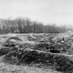
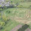
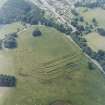
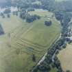
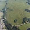
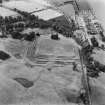
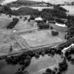
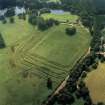
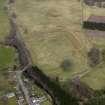
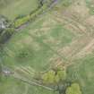
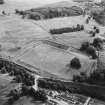
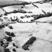
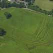
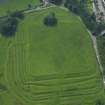
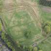
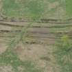
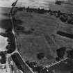
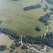
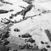
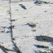
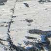
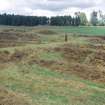
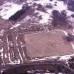
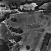
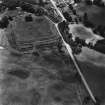
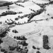
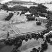
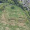
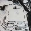
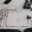
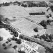
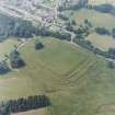
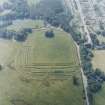
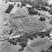
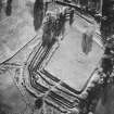
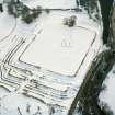
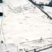
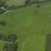
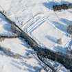
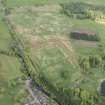
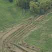
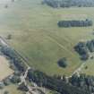
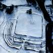
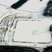
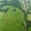
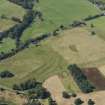
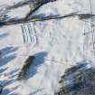
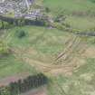
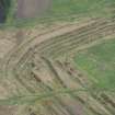
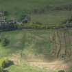
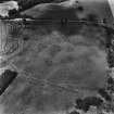
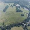
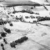
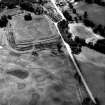
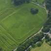
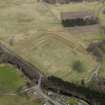
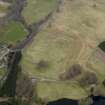
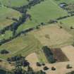
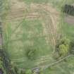
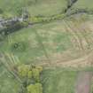
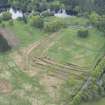
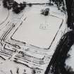
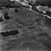
The Roman fort at Ardoch is one of the best preserved in the Roman Empire. The remains comprise a rectangular area of around two hectares, surrounded by a rampart and up to five ditches in places. It was occupied by the Roman army on several occasions, and is located by the Roman road which ran north from the Forth-Clyde isthmus. Aerial photographs have revealed cropmarks in the vicinity of the fort, representing up to six temporary marching camps and another probable fort.
Information from RCAHMS (SC) 13 August 2007
Breeze, DJ 1987
NN80NW 10 centred 8390 0990
(NN 839 099) Roman Fort (R)
(NN 840 109) The Lesser Camp (R)
(NN 841 108) The Great Camp (R).
OS 6" map (1958).
ROMAN FORT [R]
OS 1:10,000 map, [1982].
Location formerly entered as NN 839 099.
For other elements of Ardoch, Roman Military Complex , see:
NN80NW 32 NN 8425 0999 Fort (Formerly entered as Temporary Camp)
NN81SW 7 NN 8452 1075 Watch Tower (Scheduled as Signal Station)
NN81SW 15 NN 8390 1090 Temporary Camp ('63 acre')
NN81SW 16 NN 8370 1060 Temporary Camp ('30 acre')
NN81SW 17 NN 8380 1050 Temporary Camp ('13 acre': within NN81SW 16)
NN81SW 18 NN 8420 1080 Temporary Camp ('120 acre')
NN81SW 19 NN 8404 1022 Temporary Camp (Scheduled as Annexe to Fort NN80NW 10)
NN81SW 40 Camelon - Ardoch - Strageath - Cargilll Roman road (RR 9a) [Scheduled length from NN 8425 1034 to NN 8486 1127]
For bronze socketed axe found in 1896-7 during excavation of this fort [NN 8386 0993: 'at the west side of the Praetorian buildings, a few feet within the western wall'], see NN80NW 2.
For chapel and graveyard (NN 8390 0991) within the area of this fort, see NN80NW 3.
See also NN80NW 13 and NN80NW 14.
For Medieval pottery found within the area of the fort, see NN81SW 49.
The Roman auxiliary fort at Ardoch is defended by multiple ditches.
K A Steer 1964.
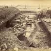
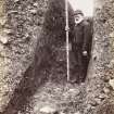
Oblong on plan, it originally enclosed an area of a little more than 6 acres, but it was subsequently shortened at the northern end and the earlier ditches incorporated in a new and very elaborate system of defence. Excavations by the Society of Antiquities of Scotland in 1896-7 disclosed that the internal buildings had been reconstructed at least twice, while the finds attested occupation in both the Flavian and Antonine periods. The fort has been tentatively identified with the Alauna of Ptolemy's Geography.
To the north of the fort are some slight remains of an annexe and of two temporary camps. The larger of these (see NN80SW 15 & 18), is one of a chain probably constructed during either the Antonine or Severan campaigns against the Caledonians. Two other temporary camps, of which no surface indications remain, have recently been identified in the vicinity of Ardoch by cropmarks (see NN81SW 16 & 17).
Roman camps (remains on Black Hill, SW of Blackhill Cottage, see NN81SW 18, and in Black Hill Wood, E of Blackhill Cottage, see NN81SW 15) and the Roman Fort are scheduled and noted on Dr J K St Joseph AP's.
D Christison 1898.
Ardoch fort, as described, is in an excellent state of preservation.
Fort re-surveyed at 1:2500.
Visited by OS(EGC) 3 July 1967.
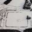
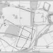
Aerial photography has enabled five different temporary works to be planned north of the fort, and excavation has proved their sequence.
A rectangular camp of 13 acres (2 on plan) was subsequently enlarged to 30 acres (3 on plan), (see as NN81SW 15-18).
A camp of 63 acres (4 on plan) overlaps near its S end both 2 and 3 so that they have some 14 acres in common. To the N side of 4, a small annexe or "attached camp" has been added (5 on plan) and a camp of 120 acres (6 on plan) overlaps in part 2, 3, 4 and 5.
The excavations showed that shortly after it was constructed the 13 acre camp was increased to 30 acres and after a considerable longer period the 63 acre camp was constructed, followed probably after a short interval by the 120 acre camp. Distrbution suggests that the 63 acre and the 120 acre camp fit the pattern of Agricola's sixth campaign and can probably be assigned to the Flavian period.
J K St Joseph 1970.
Three previously unrecorded worn denarii from Ardoch, two of Vespasian and one of Trajan were identified, in October 1966, in a collection of coins belonging to Miss Elizabeth Moncrieffe of Moncrieffe.
A S Robertson 1974.
The remains are well preserved and in excellent condition. The only part of the complex that is not published on OS plans is the small annexe (5 on plan) but there is no trace of it on the ground and no survey action could be taken.
Visited by OS (JP) 23 April 1975.
Name 'ALAVNA' accepted for 4th edition Roman Britain map.
A Roman fort at Ardoch about 3 acres in area, was identified by digging. Its centre lies at NN 8425 1000, about 350 yards NE of the centre of the well-known forts (see as NN80NW 32).
Information in letter from J K St Joseph to OS 12 October 1977.
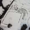
A geophysical (magnetic and electric) survey was carried out by the Archaeological Geophysics Course in the Archaeology Department of Glasgow University in early 1993, concentrating on the western part of the fort which had only been partially excavated. The intention of the survey was to identify building and other structures and in so doing to clarify some of the issues raised by the excavations in 1896-7 and 1970. The results emerging from the survey of over 4,500 sq m were very encouraging. The presence of several buildings and other remains were evident, most of which made good sense in the light of previous exploration; one interesting feature was the evidence of rebuilding, as well as the realignment of the roads. It is expected the survey will continue.
R E Jones 1993.
RAF thermal imaging has suggested that the irregularly shaped earthwork known as the procestrium, and long considered to be an annexe attatched to the N side of the fort, may have been an independent enclosure.
L J F Keppie 1995
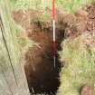
NN 838 100 During March 1996 SUAT undertook a watching brief on repair work being carried out on the modern wall alongside the A822 which retains the fort's W rampart. It was observed that the rampart was constructed with redeposited natural sand, gravel and rounded stone. No features or other deposits were seen within the fabric of the rampart and no finds were retrieved.
The new wall was built with minimum disturbance to the in situ rampart deposits and steps were taken to repair slight machine depressions on the rampart top. Behind the new wall, netting was laid to separate infill material from the fabric of the rampart.
Sponsor: Historic Scotland.
R Cachart 1996.
NN 83 09. The geophysical survey initiated in 1993 was continued by students of Glasgow University Archaeology Department. The survey revealed the existence of further structural remains, some of which had not been disturbed by the 1890s excavations of the site.
In addition to geophysical survey, small-scale optical surveys of certain parts of the fort were carried out. The areas recorded in some detail include the E gate and its immediate environs, the NE corner of the rampart complex and the E rampart itself.
Sponsor: Glasgow University.
P G Johnson 1996
NN 839 099 A survey was conducted in February 1997 at the scheduled Roman fort at Ardoch, Braco. The objective was to detail the visible extent of rabbit (and other) damage to the fort. The gorse cover had been removed and some of the trees cut prior to the survey.
A variety of sources of erosion were identified, consisting mostly of rabbit burrowing, but also including moles, gorse, trees, human activity and other natural agencies. A concentration of erosion was noted on the upstanding earthwork features of the site, which has caused significant alterations to the profiles of these ramparts in places. The southern faces of these ramparts, and the upper S facing slope of the ditches are also being eroded, most likely reflecting the preferred habitat of the rabbit on the more sheltered or sunnier slopes. The softer fills presented by the backfilled trenches of the 1896-7 excavation appear to have encouraged substantial burrowing in some of these areas (the NE, E and SW). Burrowing has also concentrated on the NE half of the interior which also underwent excavation in 1896-7. This is in direct contrast to the distribution of mole burrowing which concentrates on the unexcavated part of the fort interior.
While conducting the survey a new part of a curvilinear depression, comparable to a palisade trench, was noticed running along the inside of the outer rampart from the E entrance to the N entrance.
A copy of the report has been lodged with the NMRS.
R Strachan 1997
NN 839 099 (centre) Two sherds of 1st-century samian, found casually in the fort and annexe area, were donated to NMS (FR 1155-6).
F Hunter 1999
NN 8387 0998 Found in a fresh molehill, just inside the innermost rampart on the W side of the main Roman fort at Ardoch (NN80NW 10), part of the stone from a Roman intaglio-style ring.
It is a damaged oval in shape and reddish-amber in colour with dark inclusions. It has a typical bevelled edge to the rear. It measures 9.7 x 11 x 3.1mm. The lower portion of the intaglio has been broken off in antiquity and the engraved face is chipped, removing most of the design. On the extremes of the engraved face traces of the design survive, comprising, lower right, part of the rudder and, upper left, part of a cornucopia. Drapery folds of a central figure's clothing can also be discerned. The subject is the Goddess Fortuna. The style of cutting is coarse, consistent with an Antonine dating. The closest comparanda - Snettisham, Colchester and Slay Hill Saltings - would all appear to be 2nd century in date. Fortuna was frequently invoked by Roman soldiers and it is not surprising to find a member of the garrison at Ardoch wearing such a seal in his signet ring.
Deposited with Perth Museum.
M Hall, M Henig and N Fojut 2002
Scheduled as 'A series of superimposed forts [surviving] as substantial well-preserved earthworks....' within 'Ardoch, Roman military complex 900m NNE of Ardoch Bridge...'
Information from Historic Scotland, scheduling document dated 26 March 2008.
Field Visit (3 July 1967)
Ardoch fort, as described, is in an excellent state of preservation.
Fort re-surveyed at 1:2500.
Field Visit (23 April 1975)
The remains are well preserved and in excellent condition. The only part of the complex that is not published on OS plans is the small annexe (5 on plan) but there is no trace of it on the ground and no survey action could be taken.
Publication Account (1987)
The spectacular earthworks at Ardoch make this one of the most impressive forts in the Roman Empire. The fort has been partly excavated, but the sequence of building is not altogether certain; not surprisingly the best preserved features appear to belong to the latest phase of occupation. The rampart encloses an area of about 1.95 ha, the external ditches being particularly clear on the north and east sides; it is likely that this phase of the fort belongs to the late 150s. The rampart which lies a little way beyond the two inner most ditches on the north has been assumed to represent the northern limit of an earlier, and appreciably larger, fort, enclosing an area of some 2.5 ha. The excavations of 1896-7 indicated that the site had undergone several phases of occupation, the earlier of which dated to the Flavian period in the first century AD. The garrison in one of the earlier phases was the cohors I Hispanorum, whose presence is recorded on a tombstone found during the 17th century (now in the Hunterian Museum, University of Glasgow).
The small rectangular earthwork situated near the centre of the interior of the fort is all that survives of a medieval chapel and its enclosing bank.
The importance of the site as a halting-place on a major axis of communication may be gauged by the number of temporary camps which have been detected in the fields to the north. For the most part these can only be seen as cropmarks on air photographs, but sections of the two largest camps, dating to the campaigns of Septimius Severus, survive as upstanding banks. These earthworks may still be seen in an area of heather-covered moorland on the west side of the A 822 just north of its junction with the B 827 to Comrie. Across the corner of the field the line of part of a 25 ha camp may still be seen to the east of a post and wire fence (NN 840107). At a point about 200 m west of the road junction (just before an electricity substation) strike to the north on the east side of the fence where a long stretch of the rampart and ditch of a 52 ha camp may still be traced; one of the two side entrances to the camp can be seen at the north end of the surviving defences (NN 839109).
Information from ‘Exploring Scotland’s Heritage: Fife and Tayside’, (1987).
Geophysical Survey (1993)
A geophysical (magnetic and electric) survey was carried out by the Archaeological Geophysics Course in the Archaeology Department of Glasgow University in early 1993, concentrating on the western part of the fort which had only been partially excavated. The intention of the survey was to identify building and other structures and in so doing to clarify some of the issues raised by the excavations in 1896-7 and 1970. The results emerging from the survey of over 4,500 sq m were very encouraging. The presence of several buildings and other remains were evident, most of which made good sense in the light of previous exploration; one interesting feature was the evidence of rebuilding, as well as the realignment of the roads. It is expected the survey will continue.
Watching Brief (March 1996)
NN 838 100 During March 1996 SUAT undertook a watching brief on repair work being carried out on the modern wall alongside the A822 which retains the fort's W rampart. It was observed that the rampart was constructed with redeposited natural sand, gravel and rounded stone. No features or other deposits were seen within the fabric of the rampart and no finds were retrieved.
The new wall was built with minimum disturbance to the in situ rampart deposits and steps were taken to repair slight machine depressions on the rampart top. Behind the new wall, netting was laid to separate infill material from the fabric of the rampart.
Geophysical Survey (1996)
NN 83 09. The geophysical survey initiated in 1993 was continued by students of Glasgow University Archaeology Department. The survey revealed the existence of further structural remains, some of which had not been disturbed by the 1890s excavations of the site.
In addition to geophysical survey, small-scale optical surveys of certain parts of the fort were carried out. The areas recorded in some detail include the E gate and its immediate environs, the NE corner of the rampart complex and the E rampart itself.
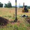
Watching Brief (18 June 2013)
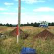
NN 84306 10602 A watching brief was kept on 18 July 2013 during the excavation of a trench for a new pole on an overhead power line within the scheduled area that encompasses a complex of Roman forts and camps to the N of Braco. Nothing of archaeological significance was encountered.
Information from OASIS (scotiaar1-155584) 23 August 2013
Archaeological Evaluation (8 April 2015 - 14 April 2016)
A programme of archaeological work was undertaken at various times, 8 April 2015 – 14 April 2016, at a range of locations during work associated with the construction of an overhead powerline.
NN 9169 2877 (Code:17) NN92NW 3 An evaluation and watching brief were undertaken, 8 April – 9 July 2015, in Glen Almond, near Crieff, in advance of the construction of scaffolding for a safety net road crossing. The evaluation concentrated on a previously recorded earthwork enclosure
just to the N of the B8063 and a hillslope to the S of the same road. A total of seven trenches were excavated covering 160.8m2. The bank and ditch forming the enclosure were found to be more ephemeral than originally thought while no archaeology was uncovered in the internal area. The date
and function of the enclosure was not determined.
NN 83936 11103 and NN 83664 10616 (Code:4000161) NN80NW 10 A watching brief was undertaken, 12 March – 12 May 2016, within the scheduled monument of Ardoch, Roman Military Complex 900m NNE of Ardoch Bridge (SM1601) as part of work to remove existing overhead line towers and wooden poles. No finds or features of archaeological significance were recorded.
NN 91249 36027 to NN 92482 29182 (Code:4408161) NN93NW 4 A watching brief was carried out, 3 October 2013 – 14 April 2016, during groundwork relating to the formation of a site compound, an underground cable
corridor and a new tower at the S end of the route. A series of field banks and dry stone walls were recorded in various states of preservation where they were divided by the underground cable route while three small clearance cairns were also uncovered.
NN 89785 33892 (Code: 4414161) An evaluation was undertaken, 31 March – 4 April 2014, at Corrymuckloch, S of Amluree, during work associated with the laying of an underground cable. The three evaluation trenches covered 20.5m2 and targeted a possible building, an adjacent mound and a probable clearance cairn, which had been identified during previous walkover surveys of the area. The remains of a likely stone and turf shieling were uncovered, while an adjacent mound was found to have a cup-marked stone at its centre with later field clearance stacked on and around it. The third trench identified a small clearance cairn of unknown date.
NN 76470 58901 (Code: 4385161) A watching brief was carried out, 19–28 November 2013, during work associated with the laying of an underground cable. No finds or features of archaeological significance were recorded.
Archive: NRHE (intended)
Funder: Scottish and Southern Energy Ltd/Scottish Hydro Electric Transmission plc
Steven Black, Peta Glew and Andrew Gallacher – Northlight Heritage
(Source: DES, Volume 17)

