
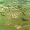
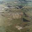
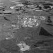
Barry Links, Barry Buddon Military Training Area


Battery (19th Century)-(20th Century), Battery (First World War)(Possible), Building(S) (20th Century)
Site Name Barry Links, Barry Buddon Military Training Area
Classification Battery (19th Century)-(20th Century), Battery (First World War)(Possible), Building(S) (20th Century)
Alternative Name(s) Buddon Camp; Buddon Links
Canmore ID 252131
Site Number NO53SW 84
NGR NO 51934 32112
NGR Description Centred on NO 51934 32112
Datum OSGB36 - NGR
Permalink http://canmore.org.uk/site/252131


- Council Angus
- Parish Barry
- Former Region Tayside
- Former District Angus
- Former County Angus
Could be WW1 training site?
Information from HS/RCAHMS World War One Audit Project (GJB) 1 October 2013.
NO53SW 84.00 centred on 51934 32112
NO53SW 84.01 NO 51877 32542 Gym; Building (Gunnery Gym)
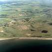
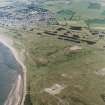
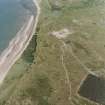
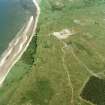
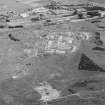
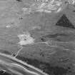
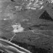
There is a long, low mound to the S of Buddon Camp (NO53SW 56.02), which is depicted on the 3rd edition of the OS 6-inch map (Angus 1920, sheet LV N.W.) and labelled as a dismantled battery. Immediately to the N there is an area of cleared ground, where three buildings that are shown on the current edition of the OS 1:10,000 map (1974) have been recently demolished. A circular hard standing lies in the centre of the vehicle turning circle to the E of the battery.
Information from RCAHMS (DCC) 21 November 2003
The circular hard standing, in the centre of the vehicle turning circle, is the former parachute training balloon inflation position.
Information from Camp Commandant, visited by RCAHMS (DCC & GDT) 6 July 2004
The battery position comprises a series of holdfasts; these are in pairs and are of increasing size, ranging from W to E. Due to the mixed nature of ordnance that would have been mounted, it is probable that this was a training battery rather than a defensive position.
Information from RCAHMS (GDT) 6 July 2004
The gun platform associated with the gunnery training building (NO53SW 84.01) is a training battery and is situated at the end of the tarmac track leading S from the main camp site about 480m to the N. The gun-emplacements are set on top of a long low earth bank measuring about 102m long by 22m wide. The platform on top measures about 84m by 6m. A small area of iron slag was found on the N side, at the western end
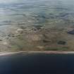
There are eight extant gun positions incorporating four smaller semi-circular concrete platforms about 5m across by about 4m deep with a centrally placed small semi-circular holdfast. The remaining four emplacements are larger, measuring about 7.5m across. Only one emplacement retains its full extent, all others have been partially demolished to reveal the pebble and concrete construction. Several of the metal plates supporting the holdfasts have a date stamped on them of 1905.
A further concrete emplacement survives at the eastern end of the embankment, at a lower level. The emplacement has no metal visible only concrete.
Within the turning circle noted above (information from Camp Commandant) and partially covered by earth and grass are two further small emplacements, similar to those at the W end of the platform.
Vertical air photographs taken in 1941 (S223, 64, flown 17 June 1941), would suggest that there was a continuation SW of the gun-positions. Examination of the mound in that area show several holes where gun platforms would have been located. The two gun positions within the turning circle can also be clearly seen on the photographs. The extension of a line of gun positions would also seem to be confirmed by the depiction on the 2nd edition of the OS 6-inch, (Forfarshire, 1903, sheet lv nw), which shows a line of at least four with a possible fifth emplacement at the W end of the heavily damaged surviving mound. Historic photographs held in the Dundee Museum show the battery with the guns mounted.
Further examination of the heavily damaged section of the western embankment revealed that five gun-emplacements still have elements surviving under the vegetation and sand. An survey arrow was used to ascertain the survival of all five emplacements visible on the 1941 air photographs and the holdfast bolts can still be seen. The visible holdfast is of a different type to those on the western embankment suggesting these may be of a later date. In addition, their plan view on the vertical air photographs of 1941 suggests a square emplacement rather than a circular one.
The 1941 air photographs also show that there were seven building or huts immediately to the N of the gun-emplacements, all of which have now been removed. The surviving small square brick built building at the extreme western end is probably the magazine.
The western embankment is protected by a sea wall, which is depicted on the 2nd edition OS map (ibid). The 1903 depiction suggests a stone construction, but the surviving remains are of concrete. The sea-wall is now about 100m from the shore, but the depiction on the 1903 map shows it to have been at the shoreline.
Visited by RCAHMS (DE, SW), 10 August and 29 November 2005
Project (March 2013 - September 2013)
A project to characterise the quantity and quality of the Scottish resource of known surviving remains of the First World War. Carried out in partnership between Historic Scotland and RCAHMS.

