
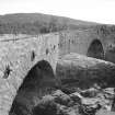
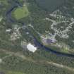
Tummel Bridge, Old Tummel Bridge


Road Bridge (18th Century) (1734)
Site Name Tummel Bridge, Old Tummel Bridge
Classification Road Bridge (18th Century) (1734)
Alternative Name(s) Canagan Bridge; River Tummel
Canmore ID 25062
Site Number NN75NE 28
NGR NN 76245 59180
Datum OSGB36 - NGR
Permalink http://canmore.org.uk/site/25062


- Council Perth And Kinross
- Parish Blair Atholl
- Former Region Tayside
- Former District Perth And Kinross
- Former County Perthshire
NN75NE 28 76245 59180
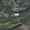
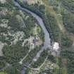
For adjacent (to NW) New Bridge, see NN75NE 81.
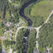
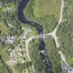
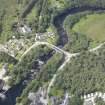
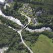
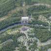
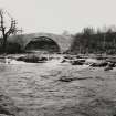
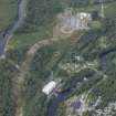
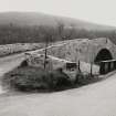
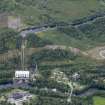
This bridge carries the military road over the River Tummel.
J B Salmond 1938.
This graceful bridge carries the military road over the river Tummel.
W Taylor 1976.
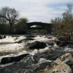
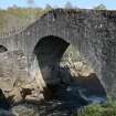
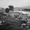
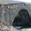
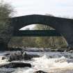
Double-arched hump-back bridge, 3.5m wide. Probably original.
Visited by OS (WDJ) February 1971.
Recently inscribed '1733 Renv. 1973'.
Visited by OS (AA) 24 October 1974.
Old Tummel Bridge, c. 1734. Constructed in rubble to carry Lt Gen George Wade's military road, the now by-passed bridge comprisesone very large hump-backed span, with a smaller (Northern) arch.
N Haynes 2000.
This bridge carries the former line of the B846 public road (formerly the military road MR3) over the River Tummel to the W of Loch Tummel and of Tummel Bridge village (NN75NE 75). The river here forms the boundary between the parishes of Dull (to the S) and Blair Atholl (to the N).
Information from RCAHMS (RJCM), 27 October 2000.

