
Dalginross


Roman Fort (Roman)
Site Name Dalginross
Classification Roman Fort (Roman)
Alternative Name(s) Victoria; Penfillan
Canmore ID 24832
Site Number NN72SE 2
NGR NN 7732 2104
NGR Description Centred NN 7732 2104
Datum OSGB36 - NGR
Permalink http://canmore.org.uk/site/24832


First 100 images shown. See the Collections panel (below) for a link to all digital images.
- Council Perth And Kinross
- Parish Comrie (Perth And Kinross)
- Former Region Tayside
- Former District Perth And Kinross
- Former County Perthshire
NN72SE 2 centred 7732 2104
(NN 773 210) Site of Roman Camp (NR)
Supposed to be Victoria (NR)
OS 6" map (1901).
For Roman temporary camp (centred NN 7742 2078), see NN72SE 1.
For Roman temporary camp (centred NN 7735 2096), see NN72SE 21.
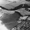
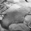
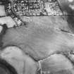
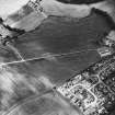
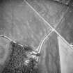
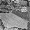
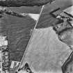
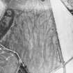
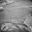
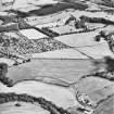
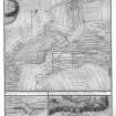
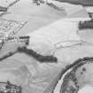
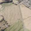
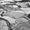
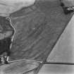
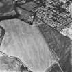
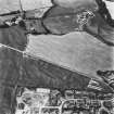
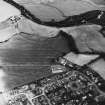
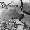
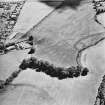
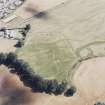
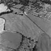
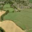
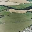
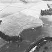
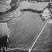
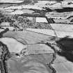
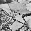
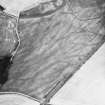
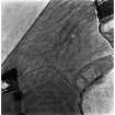
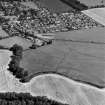
The remains of two forts probably of different ages. There is no doubt that both are Roman. Identified by Richmond with Ptolemy's Banatia (see plan). The only finds consist of a gold coin of Vespasian (AD 70-9) found here before 1786, and a coin of Domitian (AD 81-96) found within the area of the fort about 1905. A coin of Alexander Severus (AD 222-35) is said to have been picked up within or near the fort.
The causeway of a road issuing from the south gate can be traced for 800ft. Another issues from the east gate and can be traced for about the same distance. Plotted on 6" record map from ground observations of extant remains by O G S Crawford (27 June 1925).
A long trench cut in 1961 showed that the single ditch of the outer enclosure was about 16ft wide and 4ft deep. A mass of sandy turf in the ditch probably came from a collapsed rampart. No signs of occupation were found in the outer enclosure.
O G S Crawford 1949; A S Robertson 1961.
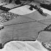
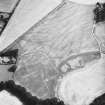
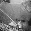
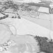
The remains of these two forts have been almost completely ploughed out, but the ramparts can still be traced as low, spread mounds; the ditches are almost non-existent. Slight traces of the roads issuing from the south and east sides can still be seen but for the lesser distances than those given by Crawford. The present whereabouts of the finds is not known.
Surveyed at 1/2500.
Visited by OS (RD), 5 December 1966.
NN 772 210. Analysis of a collection of previously unreported fieldwalking finds collected by the Cumbernauld Historical Society during the 1970s provided evidence that the fort was occupied in the Antonine period as well as the Flavian. This is the first of the so-called 'Glen blocker' forts to produce such evidence.
Sponsor: Roman Gask Project.
D J Woolliscroft 1999.
NN 772 210. This dolabra was found in 1998, whilst the finder was walking across the main path through the Scheduled Ancient Monument of Dalginross Roman fort. It was lying on the surface. It has a slightly curving profile with an oval-shaped eye around which there are two lugs. The straight blade, with a wide cutting edge, is counter-balanced by a small, chisel-pointed/adze blade. Length 409mm; width (blade) 100mm.
Allocated to Perth Museum and Art Gallery. Acc. no. 1999.377.
M Hall 1999.
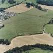
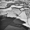
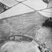
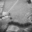
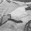
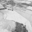
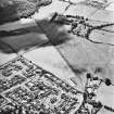
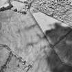
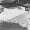
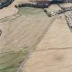
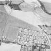
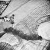
Scheduled with NN72SE 1, NN72SE 5 and NN72SE 21 as 'Dalginross, Roman fort, annexe, camp and stone circle 200m S of Penfillan... the buried remains of a complex of Roman military remains, appearing as... cropmarks on oblique aerial photographs... across the arable fields immediately to the southwest of Dalginross and to the east of the Water of Ruchill.'
Information from Historic Scotland, scheduling document dated 23 November 2010.
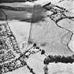
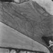
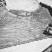
Aerial Photographic Transcription (18 November 1994)
An aerial transcription was produced from oblique aerial photographs. Information from Historic Environment Scotland (BM) 31 March 2017.
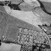
Archaeological Evaluation (May 2006)
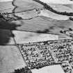
NN 774 211 An archaeological evaluation was carried out in May 2006 of a small area of land to the rear of Plot 6 in the Campfield development in Dalginross, Comrie. The site lies within a scheduled ancient monument (Dalginross Roman Forts and Camp SAM No.1612, NN72SE 2). Historic Scotland granted scheduled monument consent to evaluate the site with the objective of establishing precisely what, if any, archaeological features survive within it. The results of the evaluation were intended to inform any subsequent application for consent to undertake landscaping works in this area. Three trenches were excavated, covering a 5.5% sample of the area. The evaluation confirmed the presence of a ditch associated with the Roman fort at the S corner of the site. As predicted, the ditch had been truncated by river erosion. A second cut feature was revealed, aligned E to W. This is believed to be a 20th-century pipe trench.
The results demonstrated that the Roman-period ground surface has been destroyed by river erosion over most of the plot with potential for surviving archaeological features limited to the level area along the SE edge of the plot. Evaluation of a high proportion of this area revealed no archaeological features other than the fort ditch and the potential for currently undetected archaeological features within the plot was considered to be negligible.
Archive and report to be deposited in NMRS.
Sponsor: Mr and Mrs Hustwayte
M Dalland 2006
Excavation (14 August 2012 - 21 August 2012)
NN 7732 2104 Three trenches were opened across the line of the ditch of the outer enclosure around the Roman fort at Dalginross, 14–21 August 2012, on the site of a proposed new house and garage. The line of the ditch was located in all three trenches and the feature was bottomed in two of them. Good evidence was located for rampart demolition and backfilling of the feature, which appeared to be a single episode as there was no sign of any recuts to the ditch. The line of an ‘ankle-breaker’ in the very base of the ditch was recorded. No finds were retrieved from the backfill. In Trench 3 a contemporary drainage feature was recorded and half sectioned.
Archive: RCAHMS
Funder: Catherine Hendry
Derek Hall,
2012
Geophysical Survey (2012)
NN 7720 2100 Resistance and magnetic surveys were conducted in a pony paddock on the fort's NE corner, which had previously been known only faintly from the air. A clear image of the rampart and double ditched defences of the inner fort was obtained. The single ditch of the outer enclosure also showed well, with signs of what is probably the start of the turn into its NE corner. Inside the inner fort defences, a series of small circular features, which probably represent rampart ovens, was detected, along with a linear feature that may be a ring drain. No signs of internal buildings or other structures were found in the outer enclosure, however, and decades of aerial survey have also failed to find such structures. The fact that the inner fort shows normal internal buildings from the air might suggest that this absence is real, and not just an artefact of the data.
Outside the fort, faint signs of a narrower linear feature have been seen from the air, roughly parallel to the outer enclosure ditch, and which might have been seen as a second fort ditch. The survey confirmed the existence of this feature, but proved it to follow a more divergent course than had been thought, and a resistance pseudo-section suggested that it is extremely shallow and so probably not Roman in origin.
Archive: The Roman Gask Project
Funder: The Roman Gask Project
DJ Woolliscroft, The Roman Gask Project
2012

