
Allt A' Chaorainn


Corn Drying Kiln (Post Medieval), Township (Post Medieval)
Site Name Allt A' Chaorainn
Classification Corn Drying Kiln (Post Medieval), Township (Post Medieval)
Alternative Name(s) Allt A' Chaoruinn
Canmore ID 24634
Site Number NN69NE 6
NGR NN 6910 9990
Datum OSGB36 - NGR
Permalink http://canmore.org.uk/site/24634


- Council Highland
- Parish Kingussie And Insh
- Former Region Highland
- Former District Badenoch And Strathspey
- Former County Inverness-shire
Field Visit (28 September 1965)
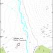
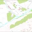
At NN 691 999, on the W bank of the Allt a' Chaoriunn there is a depopulated township comprising 7 ruined buildings, 2 small enclosures and a corn-drying kiln at NN 6909 9993.
The buildings, of two distinct periods, vary in size from 11.6m x 3.8m to 24.5m x 3.8m, with walling from grass-covered footings to 0.4 m in height.
According to Macpherson (Captain J H Macpherson, Newtonmore, Inverness-shire) this was a mill settlement which served other communities in Glen Banchor and it was deserted in the mid-19th c. Visited by OS (N K B) 28 September 1965.
Field Visit (9 November 1995)
NN69NE 6.00 6910 9990
6.01 6878 9956 Limekiln; Pit (KING95 523)
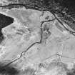
This township lies on the W bank of the Allt a' Chaorainn and comprises a cluster of seven buildings (KING95 512-6, 518-20), a kiln (KING95 517) and two enclosures, with an outlying building to the S (KING95 511).
The buildings are all of faced-rubble construction and measure up to 1m in thickness and 0.5m in height. Two of the buildings are markedly smaller than the others, measuring 6.8m by 2.5m (KING95 513) and 6.8m by 2.2m (KING95 514) internally. The other six buildings (KING95 511-2, 515-6, 518-20) measure between 10m by 3.2m (KING95 519) and 14.3m by 3m (KING95 518) internally. Two of the buildings (KING95 514, 519) can be identified as byres; both have platforms in the interiors and drains emptying out of two entrances in the same side. A further building (KING95 511) has opposed entrances and may have been a barn. Phasing within the remains of the township is evident in three of the structures (KING95 516, 518, 519). The two enclosures are both attached to buildings and in the case of the E enclosure also overlies an extensively-robbed building (KING95 516).
The corn-drying kiln (KING95 517) is situated on a ledge within the cluster of buildings. The bowl measures 2.6m in diameter within a faced-rubble bank 1m in thickness and 1.5m in depth. The flue is on the W, opening out into a subrectangular barn which measures internally 4.1m from ENE to WSW by 2.1m transversely. The entrance to the barn is on the SSE, and a pit adjacent to the flue in the interior of the barn may have been the fire-pit.
The 1st edition of the OS 6-inch map (Inverness-shire 1872, sheet ci) depicts five roofed buildings, three of which (KING95 517-9) can be identified with certainty, and an unroofed building (KING95 512).
The broad terrace to the S and SW of the township is enclosed by a dyke (KING95 510), the outer face of which is of coursed rubble, while the inner is earth embanked. The dyke runs SW from the buildings to the edge of the river terrace on the N side of the River Calder. The ground within the head-dyke has been improved but there are still faint traces of ridging and scattered heaps of clearance. Further heaps of clearance lie outside the head-dyke. A bank, which may be an earlier phase of the head-dyke, lies within the W end of the enclosed ground.
(KING95 510-520)
Visited by RCAHMS (DCC) 9 November 1995

