
Invernahavon


Corn Drying Kiln (Period Unassigned), Sheepfold (Period Unassigned), Township (Period Unassigned)
Site Name Invernahavon
Classification Corn Drying Kiln (Period Unassigned), Sheepfold (Period Unassigned), Township (Period Unassigned)
Canmore ID 24632
Site Number NN69NE 4
NGR NN 689 958
NGR Description Centred NN 689 958
Datum OSGB36 - NGR
Permalink http://canmore.org.uk/site/24632


- Council Highland
- Parish Kingussie And Insh
- Former Region Highland
- Former District Badenoch And Strathspey
- Former County Inverness-shire
NN69NE 4 centred 689 958
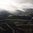
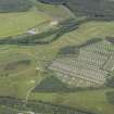
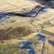
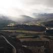
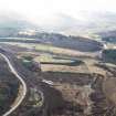
In the area centred at NN 689 958, in cultivated land at the confluence of the rivers Spey and Truim, 800 ft. OD., there is the depopulated township of Invernahavon, deserted in the mid-19th century (Information from Captain J H Macpherson, Dunmore, Newtonmore, Inverness-shire). It consists of eight buildings, of two distinct phases, varying in size from 8.5m x 4.5 m to 26.5 m x 5.5 m, three small enclosures and several field walls. A corn-drying kiln is attached to the end of one of the larger buildings. The site is now occupied by a modern sheepfold. Visited by OS (N K B) 22 September 1965.
A township, comprising one partially roofed building of three compartments, five unroofed building, an enclosure and some lengths of field-wall is depicted on the 1st edition of the OS 6-inch map (Inverness-shire 1872, sheet ci).
Five unroofed building, an enclosure and a sheepfold are shown on the current edition of the OS 1:10000 map (1971).
Information from RCAHMS (AKK), 17 July 1996.

