 |
On-line Digital Images |
SC 788736 |
Papers of Professor John R Hume, economic and industrial historian, Glasgow, Scotland |
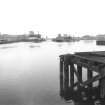
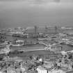
General view from WNW |
23/6/1971 |
Item Level |
|
|
Manuscripts |
MS 725/138 |
Historic Scotland Archive Project |
Report of coastal assessment survey for Historic Scotland: The Firth of Forth from Dunbar to the border of Fife. (3 volumes)
Revised version with amended text. |
1996 |
Item Level |
|
|
Manuscripts |
MS 2221/05 |
Historic Scotland Archive Project |
Survey archive: List of Vertical Aerial Photographs consulted in the NMRS, from Coastal Assessment Survey, 'The Firth of Forth from Dunbar to the Coast of Fife'. |
1996 |
Item Level |
|
 |
On-line Digital Images |
SC 1256642 |
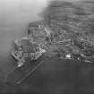
Records of Aerofilms Ltd, aerial photographers, Bristol, England |
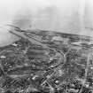
Leith Docks, Edinburgh. Oblique aerial photograph taken facing south-east. |
28/5/1929 |
Item Level |
|
 |
On-line Digital Images |
SC 1257988 |
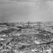
Records of Aerofilms Ltd, aerial photographers, Bristol, England |
Leith Docks, Edinburgh. Oblique aerial photograph taken facing north-east. |
5/9/1935 |
Item Level |
|
 |
On-line Digital Images |
SC 1257997 |
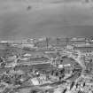
Records of Aerofilms Ltd, aerial photographers, Bristol, England |
Leith Docks, Edinburgh. Oblique aerial photograph taken facing north. |
5/9/1935 |
Item Level |
|
 |
On-line Digital Images |
SC 1258001 |
Records of Aerofilms Ltd, aerial photographers, Bristol, England |
Leith Docks, Edinburgh. Oblique aerial photograph taken facing north. |
5/9/1935 |
Item Level |
|
 |
On-line Digital Images |
SC 1259320 |
Records of Aerofilms Ltd, aerial photographers, Bristol, England |
Leith Docks, Edinburgh. Oblique aerial photograph taken facing north. |
1928 |
Item Level |
|
 |
On-line Digital Images |
SC 1259327 |
Records of Aerofilms Ltd, aerial photographers, Bristol, England |
Leith Docks, Edinburgh. Oblique aerial photograph taken facing north. This image has been produced from a damaged negative. |
1928 |
Item Level |
|
|
Photographs and Off-line Digital Images |
BP 55/06 CN |
Historic Scotland Archive Project |
Survey photographs: Leith Docks and associated buildings; Granton and Newhaven Harbours and nearby shops and houses; view of Cramond Island, harbour and foreshore with World War 2 defences; Muirhouse harbour and Portobello beach and pottery; Newhaven Chain Pier Bar; Seafield sewage works . |
1996 |
Batch Level |
|
|
Photographs and Off-line Digital Images |
BS 47/05 CS |
Historic Scotland Archive Project |
Survey photographs: Salt pans at Cockenzie and two views of the power station; boundary/sea wall at Prestonpans and the parish kirk and features of Cuthil house; aspects of Morrison's haven and the harbour at Fisherrow; Musselburgh Newfield, 2 Bush Terrace and site of pottery at West Pans; Portobello pottery and beach with groynes; Seafield sewage works; Leith Edinburgh, Albert and Victoria docks.
(no erosion photographs. Take out Tantallon and all before ) |
1996 |
Batch Level |
|
|
Photographs and Off-line Digital Images |
BS 47/06 CS |
Historic Scotland Archive Project |
Survey photographs: Leith Docks and associated buildings; Granton and Newhaven Harbours and nearby shops and houses; view of Cramond Island, harbour and foreshore with World War 2 defences; Muirhouse harbour, Portobello pottery, Newhaven Chain Pier Bar and Seafield sewage works. Views of Oxroad Bay at Tantallon Castle and ditch at Auldhame.
(take out Portobellobeach 113101) |
1996 |
Batch Level |
|
|
Manuscripts |
MS 2221/02 |
Historic Scotland Archive Project |
Survey archive: Record sheets from Coastal Assessment Survey, 'The Firth of Forth from Dunbar to the Coast of Fife'. |
1996 |
Batch Level |
|
|
Manuscripts |
MS 2221/03 |
Historic Scotland Archive Project |
Survey archive: Record sheets and maps of Erosion Units, from Coastal Assessment Survey, 'The Firth of Forth from Dunbar to the Coast of Fife'. |
1996 |
Batch Level |
|
|
Manuscripts |
MS 2221/04 |
Historic Scotland Archive Project |
Survey archive: Record sheets and maps of Geology and Coastal Geomorphology Units , from Coastal Assessment Survey, 'The Firth of Forth from Dunbar to the Coast of Fife'. |
1996 |
Batch Level |
|


