
Gypsy Point


Field Boundary(S) (Period Unassigned), Rig And Furrow (Medieval)
Site Name Gypsy Point
Classification Field Boundary(S) (Period Unassigned), Rig And Furrow (Medieval)
Canmore ID 241568
Site Number NX64SE 64
NGR NX 6852 4401
Datum OSGB36 - NGR
Permalink http://canmore.org.uk/site/241568


- Council Dumfries And Galloway
- Parish Kirkcudbright
- Former Region Dumfries And Galloway
- Former District Stewartry
- Former County Kirkcudbrightshire
NX64SE 64 6861 4412
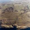
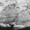
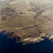
There are five fragmentary lengths of ruinous drystone wall on the broad terrace that extends northwards from Gypsy Point. All are shown on the 1st edition of the OS 6-inch map (Kirkcudbrightshire 1854, sheet 54), forming parts of a system of large subrectangular enclosures between Balmae House (NX64SE 43) and the coast. Six blocks of rig can also be seen on the terrace, lying within the enclosures. Comprising faint, straight furrows, spaced about 4m apart, the extent of the rig is best appreciated from aerial photographs (e.g. RAF 58/4957, frame No. 0007, 22 February 1962).
Visited by RCAHMS (DCC) 7 January 2003

