
Clyde Defences, Portkil Battery, Rifle Range


Firing Range (20th Century)
Site Name Clyde Defences, Portkil Battery, Rifle Range
Classification Firing Range (20th Century)
Alternative Name(s) World War I; Fort Road
Canmore ID 239764
Site Number NS28SE 39.14
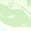
NGR NS 24918 80422
NGR Description From NS 24918 80422 to NS c.24892 80349
Datum OSGB36 - NGR
Permalink http://canmore.org.uk/site/239764

- Council Argyll And Bute
- Parish Rosneath
- Former Region Strathclyde
- Former District Dumbarton
- Former County Dunbartonshire
NS28SE 39.14 From 24918 80422 to c.24892 80349
Previously recorded as NS28SW 26.02
What may be one a shooting range for the WW I Portkil Battery situated about 100m S of the two westerly gun emplacements (NS28SE 39.01) is visible on postwar vertical air photographs (CPE/Scot/ 350, 5210-5211, flown 17 April 1948).
Information from RCAHMS (DE), March 2003
Field Visit (28 September 2016)
The remains of this firing range can be seen in woodland below and SW of the main gun-emplacements at the Portkil battery. Two parallel low earthen banks, probably firing stances, lie to the S of a target butt that takes the form of an E to W orientated bank with a ditch on the N side which is now used as a drain. Construction of a track has disturbed part of this feature.
Visited by HES Survey and Recording (AKK) 28 September 2016.

