
Rhunahaorine Point, Quadrant Tower And Bombing Target


Bombing Range (20th Century), Observation Post(S) (20th Century)
Site Name Rhunahaorine Point, Quadrant Tower And Bombing Target
Classification Bombing Range (20th Century), Observation Post(S) (20th Century)
Canmore ID 239492
Site Number NR74NW 32
NGR NR 70056 49445
NGR Description NR 70358 49952 to NR 70043 49445
Datum OSGB36 - NGR
Permalink http://canmore.org.uk/site/239492

- Council Argyll And Bute
- Parish Killean And Kilchenzie
- Former Region Strathclyde
- Former District Argyll And Bute
- Former County Argyll
NR74NW 32 70358 49952 to 70043 49445
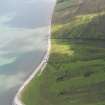
What may be a small bombing range with target indicator and observation towers is visible on postwar vertical air photographs, (RAF CPE/Scot/UK 278, 3055-3057, flown 25 August 1947). Visible as a curving track with a tower at each end with the target indicator (NR 70057 49430) next to the southern observation post. The range is also depicted on the OS 1:10000 scale map (1991) as a curving track with builidings at each end.
The observation post NR75SW 43 is almost certainly linked with this installation.
Information from RCAHMS (DE), March 2003.

