
Tighnadrochit, Quadrant Tower


Observation Post (20th Century)
Site Name Tighnadrochit, Quadrant Tower
Classification Observation Post (20th Century)
Alternative Name(s) Lenaig
Canmore ID 239487
Site Number NR75SW 43
NGR NR 71250 50369
Datum OSGB36 - NGR
Permalink http://canmore.org.uk/site/239487


- Council Argyll And Bute
- Parish Kilcalmonell
- Former Region Strathclyde
- Former District Argyll And Bute
- Former County Argyll
NR75SW 43 71250 50369
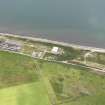
A brick and concrete observation post has been recorded by the Defence of Britain Project to the W of the A83 road, about 650m SW of Tighnadrochit farmsteading. The building is of two storeys and is visible on postwar vertical air photographs (RAF CPE/Scot/UK 278, 3054-3055, flown 25 August 1947) with an arrow shaped target indicator immediately to the S.
This structure is probably linked to the possible bombing range NR74NW 32
Information from Defence of Britain Project form, (J Cameron), 1998 and RCAHMS (DE) March 2003

