
Clach Na Briton


Boundary Marker (Period Unassigned)
Site Name Clach Na Briton
Classification Boundary Marker (Period Unassigned)
Alternative Name(s) The Minvircc; Clach Nam Breatann
Canmore ID 23884
Site Number NN32SW 2
NGR NN 3371 2161
Datum OSGB36 - NGR
Permalink http://canmore.org.uk/site/23884


- Council Stirling
- Parish Killin
- Former Region Central
- Former District Stirling
- Former County Perthshire
NN32SW 2 3371 2161
(NN 3371 2161) Clach na Briton (NAT)
OS 6" map, Perthshire, 2nd ed., (1901).
See also NN20SW 3 and NN32SW 3.
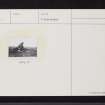
Clach nam Breatann (identified by Lacaille {1929} with OS published site) is a group of piled schistose megalithis. Its base is a conical knoll, 180 feet in circumference and c.12 feet high situated in an arena-like depression in a grassy plateau. The capstone seems to have been originally part of the stones upon which it lies and, together, they are 15 1/2 feet high. Its name is mentioned as a bound-mark in 16/17th century references and an 8th century battle is said to have been fought near the stone (NN32SW 3) which was then called "Minvircc".
A D Lacaille 1929.
This is a prominent natural outcrop with strata inclined to the south, height 4.5 metres.
Visited by OS (R D L), 3 May 1962.
As described by previous OS field surveyor.
Visited by OS (W D J), 24 April 1969.
NN 337 216 The possible historical importance of this mound, although recorded on the OS maps (as Clach na Briton, NMRS NN32SW 2) and in the Name Book, has not been recognised. It is traditionally said to mark the junction of the ancient kingdoms of Dalriada, Pictland and Strathclyde.
It lies on the gently sloping W side of Glen Falloch on open moorland above the Falls of Falloch at an altitude of about 240m OD. It appears to be at least partly man-made; it is a circular mound 18m in diameter and about 8m high. Set into the sides of the mound and encircling it is a series of large boulders about 1m in size. Protruding from the top is one large jagged boulder c 5 x 3 x 3m which rests on other large rough boulders; these are deeply set and might be rock outcrop. The mound does not have the appearance nor the features of a burial cairn.
The significance of the mound is that about 10km to the S above Lochgoilhead there is a huge erratic boulder known as the Clach nam Breatunnaich (NMRS NN20SW 3) which is said to be the boundary stone between the Scotti and the British; 24km to the W in Morvern there is another apparently artificial hummock which also looks man-made (NM 688 519) though not a burial cairn. A line between these three points, extending from the extremities to the S and W there is a series of placenames incorporating the Gaelic words 'Criche' and 'Fala'. These both mean boundary. The postulated boundary line crosses the highest points of the most southerly and westerly of the Highland Massive. Where the line must cross low-lying ground it is marked by fortified monuments - duns, forts and castles.
E B Rennie 1996.

