
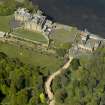
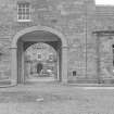
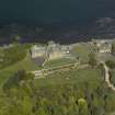
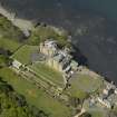
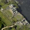
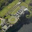
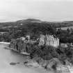
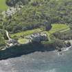
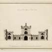
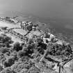
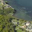
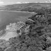
Culzean Castle, Stables And Clock Tower


Clock Tower (Period Unassigned), Stable(S) (Period Unassigned)
Site Name Culzean Castle, Stables And Clock Tower
Classification Clock Tower (Period Unassigned), Stable(S) (Period Unassigned)
Canmore ID 238249
Site Number NS21SW 27
NGR NS 23353 10317
Datum OSGB36 - NGR
Permalink http://canmore.org.uk/site/238249


- Council South Ayrshire
- Parish Kirkoswald
- Former Region Strathclyde
- Former District Kyle And Carrick
- Former County Ayrshire
Stable and the clock tower remodelled by Robert Adam c. 1777 incorporating an earlier building.
Photographed in 2009 on behalf of the Buildings of Scotland publications.
RCAHMS (CAJS) 2009.
Watching Brief (23 October 2014 - 29 January 2015)
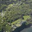
Archaeological monitoring works were carried out in respect to various ground breaking works around the grounds and estate of Culzean Castle, Maybole, South Ayrshire. The archaeological works were designed to mitigate the impact on the archaeological remains within their development area. The works carried out did not identify the presence of any significant archaeological features. The only archaeological features present were those relating to modern 19th to 21st century activity.
The programme of works comprised the archaeological monitoring of ground breaking at three areas around Culzean Castle and the Culzean Estate (Figure 1). The three areas were:
1. the garden to the located to the immediate west of the Clock Tower (NGR: NS23352 10306),
2. the Waste Chute (NGR: NS23392 10313) located 10m to the east of the Clock Tower Complex.
3. Hogston Burn Cundie (NGR 2287 0927) which is a culvert under a bend in one of the estate paths, which lies 43m NW of the Swinston or Cat Gates
OASIS ID: rathmell1-202790 (T Rees) 2015

