 |
On-line Digital Images |
SC 721365 |
Papers of Helen Cameron Nisbet, geologist and archaeologist, Lasswade, Midlothian, Scotland |
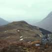
Copy of colour slide showing view of Dun Deardail, Glen Nevis, Highland. View of fort from S.
( slopes of Sgor Chalum) 1127ft above sea level
NMRS Survey of Private Collection
Digital Image Only |
3/3/1968 |
Item Level |
|
 |
On-line Digital Images |
SC 721368 |
Papers of Helen Cameron Nisbet, geologist and archaeologist, Lasswade, Midlothian, Scotland |
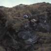
Copy of colour slide showing view of Dun Deardail, Glen Nevis, Highland. Large stones, possibly of outer facing wall
NMRS Survey of Private Collection
Digital Image Only |
3/3/1968 |
Item Level |
|
 |
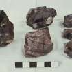
On-line Digital Images |
SC 721372 |
Papers of Helen Cameron Nisbet, geologist and archaeologist, Lasswade, Midlothian, Scotland |
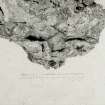
Copy of black and white slide showing detail of vitrification Dun Deardail, Glen Nevis, Highland. " Vitrification containing wood casts showing cross section of a log."
NMRS Survey of Private Collection
Digital Image Only |
|
Item Level |
|
 |
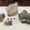
On-line Digital Images |
SC 721373 |
Papers of Helen Cameron Nisbet, geologist and archaeologist, Lasswade, Midlothian, Scotland |
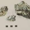
Copy of colour slide showing detail of "agglomeratic" vitrification
Dun Deardail, Glen Nevis; Meall an Iarnuim, Inverpolly; Rubh'Aird Ghamhsgail, Arisaig
NMRS Survey of Private Collection
Digital Image Only |
3/1968 |
Item Level |
|
 |
On-line Digital Images |
SC 723497 |
Papers of Helen Cameron Nisbet, geologist and archaeologist, Lasswade, Midlothian, Scotland |
Copy of colour slide showing details of Agglomeratic or Agglutinate types of vitrification.
Back: volc. Breccia, Buckstone quarry, Mortonhall
Front: vitrification in: Dun Deardail, Nevis; Meall an Iarnuim, Inverpolly;
Rubh' Aird Ghamsgail Arisaig.
NMRS Survey of Private Collection
Digital Image Only |
3/1968 |
Item Level |
|
 |
On-line Digital Images |
SC 723518 |
Papers of Helen Cameron Nisbet, geologist and archaeologist, Lasswade, Midlothian, Scotland |
Copy of colour slide showing details of vitrification; showing disruption of blocks and gradation of natural banding into frothy "matrix"
Left: vitrification, Dun Deardail, Nevis;
Top and right: vitrification Rubh' Aird Ghamsgail Arisaig.
Bottom centre: natural xenoliths in pink granite (?Ross of Mull)
NMRS Survey of Private Collection
Digital Image Only |
3/1968 |
Item Level |
|
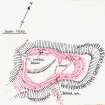 |
On-line Digital Images |
SC 1473052 |
Records of the Ordnance Survey, Southampton, Hampshire, England |
Plan, copied from OS '495' card |
7/1961 |
Item Level |
|
 |
On-line Digital Images |
DP 230720 |
Records from Headland Archaeology Ltd, archaeologists, Edinburgh, Scotland |
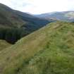
Dun Deadrail, slight erosion on top of north rampart, illustration 9 from a report on a topographic archaeological survey at five Pictish Forts in the Highlands |
9/2010 |
Item Level |
|
 |
On-line Digital Images |
DP 230808 |
Records from Headland Archaeology Ltd, archaeologists, Edinburgh, Scotland |
View towards Fort William from Dun Deardail, photograph from a topographic archaeological survey at five Pictish Forts in the Highlands |
9/2010 |
Item Level |
|
 |
On-line Digital Images |
DP 230809 |
Records from Headland Archaeology Ltd, archaeologists, Edinburgh, Scotland |
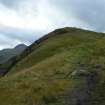
View along inside of south rampart, photograph of Dun Deardail, from a topographic archaeological survey at five Pictish Forts in the Highlands |
9/2010 |
Item Level |
|
 |
On-line Digital Images |
DP 230810 |
Records from Headland Archaeology Ltd, archaeologists, Edinburgh, Scotland |
View of fort interior from the east, photograph of Dun Deardail, from a topographic archaeological survey at five Pictish Forts in the Highlands |
9/2010 |
Item Level |
|
 |
On-line Digital Images |
DP 230811 |
Records from Headland Archaeology Ltd, archaeologists, Edinburgh, Scotland |
View along inside of north rampart, photograph of Dun Deardail, from a topographic archaeological survey at five Pictish Forts in the Highlands |
9/2010 |
Item Level |
|
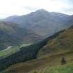 |
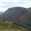
On-line Digital Images |
DP 230812 |
Records from Headland Archaeology Ltd, archaeologists, Edinburgh, Scotland |
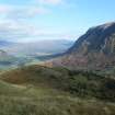
View towards Glen Nevis from Dun Deardail, from a topographic archaeological survey at five Pictish Forts in the Highlands |
9/2010 |
Item Level |
|
 |
On-line Digital Images |
DP 230813 |
Records from Headland Archaeology Ltd, archaeologists, Edinburgh, Scotland |
View towards Glen Nevis from Dun Deardail, from a topographic archaeological survey at five Pictish Forts in the Highlands |
9/2010 |
Item Level |
|
 |
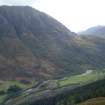
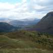
On-line Digital Images |
DP 230814 |
Records from Headland Archaeology Ltd, archaeologists, Edinburgh, Scotland |
View towards Ben Nevis from Dun Deardail, from a topographic archaeological survey at five Pictish Forts in the Highlands |
9/2010 |
Item Level |
|
 |
On-line Digital Images |
DP 230815 |
Records from Headland Archaeology Ltd, archaeologists, Edinburgh, Scotland |
View towards north side of Ben Nevis from Dun Deardail, from a topographic archaeological survey at five Pictish Forts in the Highlands |
9/2010 |
Item Level |
|
 |
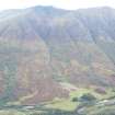
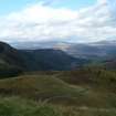
On-line Digital Images |
DP 230816 |
Records from Headland Archaeology Ltd, archaeologists, Edinburgh, Scotland |
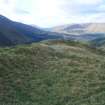
View towards Meall an t-Suidhe from Dun Deardail, from a topographic archaeological survey at five Pictish Forts in the Highlands |
9/2010 |
Item Level |
|
 |
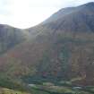
On-line Digital Images |
DP 230817 |
Records from Headland Archaeology Ltd, archaeologists, Edinburgh, Scotland |
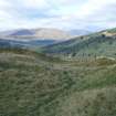
View towards Fort William from Dun Deardail, from a topographic archaeological survey at five Pictish Forts in the Highlands |
9/2010 |
Item Level |
|
 |
On-line Digital Images |
DP 230818 |
Records from Headland Archaeology Ltd, archaeologists, Edinburgh, Scotland |
View towards Fort William from Dun Deardail, from a topographic archaeological survey at five Pictish Forts in the Highlands |
9/2010 |
Item Level |
|
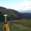 |
On-line Digital Images |
DP 230819 |
Records from Headland Archaeology Ltd, archaeologists, Edinburgh, Scotland |
GPS base receiver, photograph of Dun Deardail, from a topographic archaeological survey at five Pictish Forts in the Highlands |
9/2010 |
Item Level |
|
 |
On-line Digital Images |
DP 230820 |
Records from Headland Archaeology Ltd, archaeologists, Edinburgh, Scotland |
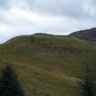
View towards Dun Deardail from the north, photograph from a topographic archaeological survey at five Pictish Forts in the Highlands |
9/2010 |
Item Level |
|
 |
On-line Digital Images |
DP 230821 |
Records from Headland Archaeology Ltd, archaeologists, Edinburgh, Scotland |
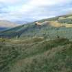
Steep crags on the east side of Dun Deardail, from a topographic archaeological survey at five Pictish Forts in the Highlands |
9/2010 |
Item Level |
|
 |
On-line Digital Images |
DP 230822 |
Records from Headland Archaeology Ltd, archaeologists, Edinburgh, Scotland |
View along south rampart of Dun Deardail, from a topographic archaeological survey at five Pictish Forts in the Highlands |
9/2010 |
Item Level |
|
 |
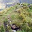
On-line Digital Images |
DP 230823 |
Records from Headland Archaeology Ltd, archaeologists, Edinburgh, Scotland |
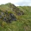
Two vitrified blocks along outside of south rampart of Dun Deardail, from a topographic archaeological survey at five Pictish Forts in the Highlands |
9/2010 |
Item Level |
|


