 |
On-line Digital Images |
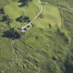
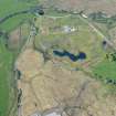
DP 017810 |
RCAHMS Aerial Photography Digital |
Oblique aerial view centred on the remains of the dun and buildings, taken from the NE. |
27/6/2006 |
Item Level |
|
 |
On-line Digital Images |
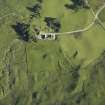
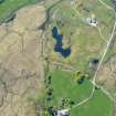
DP 017811 |
RCAHMS Aerial Photography Digital |
Oblique aerial view centred on the remains of the dun and buildings, taken from the WNW. |
27/6/2006 |
Item Level |
|
 |
On-line Digital Images |
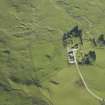
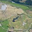
DP 017812 |
RCAHMS Aerial Photography Digital |
Oblique aerial view centred on the remains of the dun and buildings, taken from the WSW. |
27/6/2006 |
Item Level |
|
 |
On-line Digital Images |
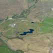
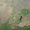
DP 297323 |
Historic Environment Scotland |
Oblique aerial view. |
14/5/2019 |
Item Level |
|
 |
On-line Digital Images |
DP 297324 |
Historic Environment Scotland |
Oblique aerial view. |
14/5/2019 |
Item Level |
|
 |
On-line Digital Images |
DP 297325 |
Historic Environment Scotland |
Oblique aerial view. |
14/5/2019 |
Item Level |
|
 |
On-line Digital Images |
DP 297326 |
Historic Environment Scotland |
Oblique aerial view. |
14/5/2019 |
Item Level |
|
 |
On-line Digital Images |
DP 297327 |
Historic Environment Scotland |
Oblique aerial view. |
14/5/2019 |
Item Level |
|
 |
On-line Digital Images |
SC 2386163 |
Records of the Ordnance Survey, Southampton, Hampshire, England |
Castles Farm, NN12NW 14, Ordnance Survey index card, page number 1, Recto |
1958 |
Item Level |
|


