
Girdstingwood Dairy


Building(S) (Period Unassigned), Sheep House(S) (Post Medieval)(Possible)
Site Name Girdstingwood Dairy
Classification Building(S) (Period Unassigned), Sheep House(S) (Post Medieval)(Possible)
Canmore ID 235972
Site Number NX74NW 146
NGR NX 7400 4648
Datum OSGB36 - NGR
Permalink http://canmore.org.uk/site/235972


- Council Dumfries And Galloway
- Parish Rerrick
- Former Region Dumfries And Galloway
- Former District Stewartry
- Former County Kirkcudbrightshire
NX74NW 146 7400 4648
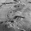
The remains of two buildings are situated in a patch of rough ground at the edge of an improved field to the WNW of Girdstingwood Dairy. They are set parallel to each other, lying from WNW to ESE along the sides of a square courtyard. The southern building stands to gable height and measures 18.4m by 3.3m within faced rubble walls 0.6m in thickness (KTA02 331). There are three entrances in the NNE side, that to the ESE wide enough to accommodate a cart. The second building (KTA02 332) has been reduced to footings no more than 0.5m in height and is partly obscured by field clearance, but it is the same size as the southern building. The buildings are shown as roofed on the 1st and 2nd editions of the OS 6-inch map (Kirkcudbrightshire 1854, sheet 55; 1896, sheet lv S.E.) and are annotated sheds on the earlier map. The disposition of these buildings along the sides of a yard and set up on a hillside away from the farm suggests that they may have been sheep-houses.
(KTA02 331-2).
Visited by RCAHMS (DCC) 8 January 2003

