
Cnocan Dubha


Fort (Period Unassigned)
Site Name Cnocan Dubha
Classification Fort (Period Unassigned)
Canmore ID 23549
Site Number NN05NE 6
NGR NN 0799 5851
Datum OSGB36 - NGR
Permalink http://canmore.org.uk/site/23549


- Council Highland
- Parish Lismore And Appin (Lochaber)
- Former Region Highland
- Former District Lochaber
- Former County Argyll
NN05NE 6 0799 5851.
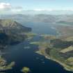
NN 0799 5851. On the summit of the more northerly of the two rocky prominences known as Cnocan Dubh, are the slight remains of a stone-walled fort. The NE and SE sides are protected by sheer rock faces whilst on the south some protection is afforded by a low crescent-shaped scarp. Elsewhere, however, the approach is over a grassy slope of only moderate steepness. The fort measures internally about 36 metres E-W by 27 metres transversely.
No trace of any defences are discernible on the eastern perimeter, but it is probable that the fort was originally defended by a wall drawn round the whole of the irregular summit area with an outwork to restrict progress on the more vulnerable west flank.
The surviving portion of the main wall is on the west side and appears as a low grass-grown spread of core material ranging in width from 0.6 to 2.4 metres. No inner or outer facing stones are now visible. A similar band of debris, 1.5 metres in its greatest width, indicates the course of the outer wall.
The entrance was on the west side and is indicated by gaps in the inner and outer walls measuring 1.8 metres and 5.1 metres respectively. The interior is mainly bare rock.
RCAHMS 1975, visited May 1971.
As described.
Surveyed at 1:2500 scale.
Visited by OS (J L D) 25 April 1972.
NN 0811 5844 (centre) A watching brief was undertaken on a house plot and associated access, to the SE of Cnocan Dubh fort (NN05SE 6). No archaeological features or deposits were found.
Full report lodged with Highland SMR and the NMRS.
Sponsor: Mr P Watt.
S Farrell 2002
Field Visit (May 1971)
NN 079 585. On the summit of the more northerly of the two rocky prominences known as Cnocan Dubh, immediately N of the village of East Laroch, there are the tenuous remains of a stone-walled fort. The boss, which rises to a hieght of about 18m above the surrounding coastal plain, is protected on the NE and SE sides by sheer rock faces, but elsewhere, apart from a low crescentic scarp on the E, the immediate approach is over a grassy slope of only moderate steepness.
Although no trace of any defences can now be seen on the E half of the perimeter, it is probably that the fort, which measures internally about 36m E-W by 27m transversely, was originally defended by a wall drawn round the whole of the irregular summit area, with an outwork to restricting access on the more vulnerable W flank. The surviving portion of the main wall appears as a grass-grown spread of core material, 0.6m to 2.4m wide in which no inner or outer facing stones are now visible. A similar band of debris, although only 1.5m in greatest width, indicates the course of the outer wall.
The entrance lay on the W, its position being marked by gaps in the inner wall and the outwork measuring 1.8m and 5.1m respectively. The interior is largely occupied by bare rock.
RCAHMS 1975, visited May 1971.
As described.
Surveyed at 1:2500 scale.
Visited by OS (J L D) 25 April 1972.
NN 0811 5844 (centre) A watching brief was undertaken on a house plot and associated access, to the SE of Cnocan Dubh fort (NN 05 SE 6). No archaeological features or deposits were found.
Full report lodged with Highland SMR and the NMRS.
Sponsor: Mr P Watt.
S Farrell 2002
Measured Survey (24 May 1971)
Measured survey at 1mm:1ft. Redrawn in ink and published at 1:1000 (RCAHMS 1971, fig. 30).
Note (3 December 2014 - 18 May 2016)
This small fortification is configured as a promontory work on the northern of two rocky bosses immediately N of East Laroch. The boss falls sheer on the NE and SE, while access across the gentler approaches from the NW and SW is blocked by two roughly concentric walls, the upper of which has been drawn around the margin of the summit on this side to enclose a triangular area measuring about 36m from E to W by a maximum of 27m transversely (0.05ha). The entrance faces W midway along the arc of defences. The featureless interior is largely bare rock
Information from An Atlas of Hillforts of Great Britain and Ireland – 18 May 2016. Atlas of Hillforts SC2605

