
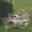
Ugston Old Farm


Farmstead (16th Century)
Site Name Ugston Old Farm
Classification Farmstead (16th Century)
Canmore ID 234085
Site Number NT47SE 48.01
NGR NT 49303 74700
Datum OSGB36 - NGR
Permalink http://canmore.org.uk/site/234085


- Council East Lothian
- Parish Haddington
- Former Region Lothian
- Former District East Lothian
- Former County East Lothian
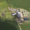
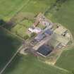
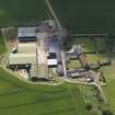
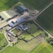
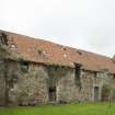
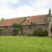
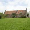
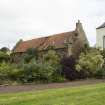
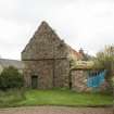
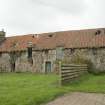
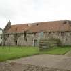
Early farm steading probably designed as such. 2-storey, irregular 6-bay, very thick walls in variegated random rubble on boulder base course, dressing eroded but chamfering discernible.
An intriguing building, once of some importance, on which detailed information is not readily forthcoming. The stonework suggests that the upper floor was added later, albeit at an early date - the lower storey being of rough field stones while the upper storey is clearly of more massive angular whinstone, probably quarried. In addition, both gables (more obviously the southern gable) suggest a raggle (or "ghost") of a former lower gable. The form of the skews and the depth between them and the current pantiled roof strongly suggests that the roof was previously thatched. Referred to as "Heukston" on 1736 Map. (Historic Scotland)
Note (12 October 2011)
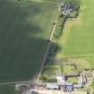
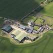
Ugston Old Farmsteading was previously incorrectly located on the modern farmstead of Ugston. Its location has been corrected to NT 49303 74700.
Information from RCAHMS (LMcC) 12 October 2011
Note
Photographed for the Listed Building Survey programme in 2017 for archive record upgrade.

