
Islay, Kildalton 8


Cross (Medieval)
Site Name Islay, Kildalton 8
Classification Cross (Medieval)
Canmore ID 233550
Site Number NR45SE 3.02
NGR NR 45840 50870
Datum OSGB36 - NGR
Permalink http://canmore.org.uk/site/233550


- Council Argyll And Bute
- Parish Kildalton And Oa
- Former Region Strathclyde
- Former District Argyll And Bute
- Former County Argyll
External Reference (20 July 1971)
Mediaeval. Monolith. Disc type. Scroll ornament on stem. On
small cairn.
O.S.A.
N.S.A.
T.S.A.
Argyll C.C. 'List'
Muir 'Characteristics' P.105
Graham 'Carved Stones' P.89 (ills.)
RCAHMS Vol 5 No. 367
Scheduled Ancient Monument No 2379.
Information from Historic Scotland, 20 July 1971
Field Visit (June 1982)
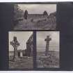
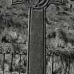
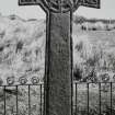
(8) Free-standing disc-headed cross with splayed arms erected on an artificial stony mound enclosed by a ditch and bank 7m in overall diameter. The cross is 1.94m in visible height, the diameter of the disc-head 0.40m and the span the arms 0.75m; the shaft tapers from 0.28m by 0.15m at ground level to 0.23m by 0.12m at the neck. Each face bordered by a roll-moulding, the shaft and edges being undecorated. The ornament of the E face of the cross-head comprises a cross with round armpits and a small central boss, interlaced with two concentric circles and terminating in the upper and side-arms in ring-knots. The W face bears more intricate plaitwork cross with central boss and foliate terminals incorporating in the left arm a saltire and in the upper arm a Latin cross. (Stuart 1867; Graham 1895, shows E face only), lona school, 14th-15th century.
RCAHMS 1984, visited June 1982
Project (25 March 2017 - 1 April 2017)
NR 45804 50830 A geophysical and walkover survey of the environs of the 8th-century Kildalton High Cross was undertaken, 25 March – 1 April 2017, by a group of University of Glasgow archaeologists. The survey did not find any clear evidence of an early Christian vallum or any feature which may relate to pre-existing structures immediately outside the churchyard of Kildalton. The churchyard was found to have rig and furrow cultivation in the suitable flat ground around it, which may have removed any trace of earlier features. The area immediately W of the churchyard enclosure is subsumed under a raft of field clearance and it is recommended that this area be cleared and evaluated with trial trenching to test the integrity of the archaeological deposit.
Geophysical survey using both earth resistance and gradiometry techniques in the Lon an t-Sagairt field to the N revealed possible linear features and an apparent rectilinear enclosure, but these did not appear to relate to the church site above. Walkover survey identified part of the main rampart of the hillfort at Creagan na Ceardaich Mor to the N of the church, along with an upstanding rectilinear banked structure at its lower slope. These stone and turf-defined features and a single 20 x 10m area of the hillfort summit were surveyed with resistivity but proved inconclusive due to field clearance and heavy overgrowth of vegetation. It is recommended that the hillfort and banked structures at its foot be cleared and properly recorded with the aim of identifying possible dating by morphology.
Finally, preliminary photogrammetric models were created from the Kildalton High Cross and the adjacent Thief’s Cross by Heather Christie which raise new questions about the monuments and their setting; these are now available to view online via Sketchfab. The cairn of the Thief’s Cross is set within a peculiar ring ditch with outer bank, which is shown to be sub-square in form by the digital model; it is possible that this medieval cross is set atop a reused ancient burial monument but only excavation may shed more light. It is recommended that a full photogrammetric survey of the early and late medieval stones be carried out for conservation
purposes.
Archive: NRHE
Funder: Historic Environment Scotland
Adrian Maldonado – University of Glasgow
(Source: DES, Volume 18)
OASIS ID: universi22-285817
Magnetometry (25 March 2017 - 1 April 2017)
NR 45804 50830 A gradiometry survey of the environs of the 8th-century Kildalton High Cross was undertaken, 25 March – 1 April 2017, by a group of University of Glasgow archaeologists.
Archive: NRHE
Funder: Historic Environment Scotland
Adrian Maldonado – University of Glasgow
(Source: DES, Volume 18)
OASIS ID: universi22-285817
Resistivity (25 March 2017 - 1 April 2017)
NR 45804 50830 A resistance survey of the environs of the 8th-century Kildalton High Cross was undertaken, 25 March – 1 April 2017, by a group of University of Glasgow archaeologists.
Archive: NRHE
Funder: Historic Environment Scotland
Adrian Maldonado – University of Glasgow
(Source: DES, Volume 18)
OASIS ID: universi22-285817

