
Townhead, Civil Starfish Decoy


Decoy Site (20th Century)
Site Name Townhead, Civil Starfish Decoy
Classification Decoy Site (20th Century)
Alternative Name(s) Clyde Aa Defences; Townhead; Gartcosh Road, Starfish
Canmore ID 232039
Site Number NS76NW 149
NGR NS 701 661
Datum OSGB36 - NGR
Permalink http://canmore.org.uk/site/232039

- Council North Lanarkshire
- Parish Old Monkland (Monklands)
- Former Region Strathclyde
- Former District Monklands
- Former County Lanarkshire
NS76NW 149 701 661
The remains of a Starfish decoy site (SF13h) are visible at this location on RAF air photographs (CPE/Scot/UK277: 5426 and 5427, flown 24 August 1947). The remains are not visible on All Scotland Survey air photographs taken in 1988 (51588: 157, 158).
Information from RCAHMS (KM) 27 December 2002.
Field Visit (3 October 2017)
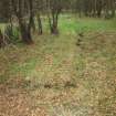
Five small concrete platforms are all that has been observed of this World War Two Civil Starfish Decoy, which is visible on RAF air photographs (CPE/Scot/UK277: 5426 and 5427) flown 24 August 1947. The site is one of 18 decoys that were constructed as part of the military infrastructure designed to protect the industries in the centre of Glasgow and along the banks of the River Clyde from aerial attack.
Although the location of the control shelter is unknown, the platforms confirm that at least parts of the decoy survive. One (NS 70261 66156) is situated in deciduous woodland about 25m SE of a path leading from the edge of Lochend Loch to the A752 public road, three (NS 70204 66102, NS 70181 66106 and NS 70162 66094) occur at the edge of a clearing to the SW, while another (NS 70080 66174), measuring 6m from NNE to SSW by 1m, is located in woodland between the A752 public road and the M73 motorway. All are flush with the ground and heavily obscured by grass or bracken.
Visited by HES, Survey and Recording (ATW, JRS) 3 October 2017.

