|
Manuscripts |
MS 810/11 |
Records of Historic Scotland, Edinburgh, Scotland |
Strathclyde Region. A survey of the 20th century defences. Survey by John Guy 1992-1999.
Four volumes
|
14/4/2001 |
Item Level |
|
|
Manuscripts |
MS 2043/608 |
Records of the Council for British Archaeology, York, England |
Defence of Britain Project. Council of British Archaeology.
Renfrewshire.
Details of the remains of a Bombing Decoy Site located on Gleniffer Braes, Paisley. |
8/6/97 |
Item Level |
|
|
Digital Files (Non-image) |
GV 007017 |
Historic Environment Scotland |
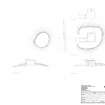
DES plan of Gleniffer Braes decoy control bunker |
22/1/2019 |
Item Level |
|
|
Prints and Drawings |
DC 57786 |
Historic Environment Scotland |
Plan and section of Gleniffer Braes decoy control centre |
29/10/2018 |
Item Level |
|
 |
On-line Digital Images |
SC 1777692 |
Historic Environment Scotland |
Plan and sections of Gleniffer Braes decoy control centre |
29/10/2018 |
Item Level |
|
 |
Digital Files (Non-image) |
WP 006789 |
Records of CFA Archaeology Ltd, archaeologists, Musselburgh, East Lothian, Scotland |
Report: 'Replacement overhead line (XF route) Neilston, Renfrewshire to Windyhill, East Dunbartonshire, Cultural Heritage Baseline', February 2012 |
2/2012 |
Item Level |
|
|
Digital Files (Non-image) |
GV 008404 |
Historic Environment Scotland |
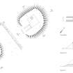
Gleniffer Braes decoy control bunker, plan and sections |
12/2020 |
Item Level |
|
 |
On-line Digital Images |
SC 2145019 |
Historic Environment Scotland |
Gleniffer Braes decoy control bunker, plan and sections |
12/2020 |
Item Level |
|
 |
On-line Digital Images |
DP 352316 |
RCAHMS digital photography |
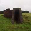
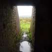
The entrance to the control shelter from the SW |
25/8/2017 |
Item Level |
|
 |
On-line Digital Images |
DP 352317 |
RCAHMS digital photography |
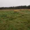
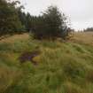
A small circular earthwork with an encircling bank and a central mound |
25/8/2017 |
Item Level |
|
 |
On-line Digital Images |
DP 352318 |
RCAHMS digital photography |
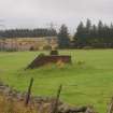
The control shelter from the S |
25/8/2017 |
Item Level |
|
 |
On-line Digital Images |
DP 352319 |
RCAHMS digital photography |
Looking out to the SW from the entrance of the control shelter |
25/8/2017 |
Item Level |
|
 |
On-line Digital Images |
DP 352320 |
RCAHMS digital photography |
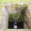
The view from the escape hatch in the roof showing the rungs against the NW wall |
25/8/2017 |
Item Level |
|
 |
On-line Digital Images |
DP 352321 |
RCAHMS digital photography |
A rectangular building platform (NS 44791 60333) from the W |
25/8/2017 |
Item Level |
|
|
Digital Files (Non-image) |
TM 001303 |
Historic Environment Scotland |
GNSS linework relating to Aerial Defences of the Clyde Project |
4/2017 |
Item Level |
|
|
All Other |
551 30/9/47 |
Records of CFA Archaeology Ltd, archaeologists, Musselburgh, East Lothian, Scotland |
Archive from a cultural heritage assessment for a replacement overhead line (XF Route) Neilston, Renfrewshire to Windyhill, East Dunbartonshire. |
9/2011 |
Sub-Group Level |
|


