
Inverbervie, Kinghornie


Pillbox (20th Century)
Site Name Inverbervie, Kinghornie
Classification Pillbox (20th Century)
Alternative Name(s) Bervie Bay
Canmore ID 231396
Site Number NO87SW 125
NGR NO 83607 72524
Datum OSGB36 - NGR
Permalink http://canmore.org.uk/site/231396


- Council Aberdeenshire
- Parish Arbuthnott
- Former Region Grampian
- Former District Kincardine And Deeside
- Former County Kincardineshire
NO87SW 125.00 83607 72524
NO87SW 125.01 From NO 83611 72521 to NO 83612 72486 Anti-tank Blocks
NO87SW 125.02 From NO 83384 72471 to NOc.8327 7210 Anti-tank Blocks
NO87SW 125.03 NO 8326 7214 Pillbox
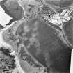
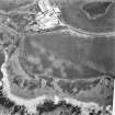
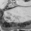
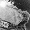
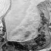
A pillbox of unknown type is situated at the northern end of Bervie Bay on the N side of the Bervie Water where it enters the sea. A line of twelve anti-tank blocks runs from the pillbox to the high water mark. A further line of anti-tank blocks running on to the shingle bank has been noted to the E and S of the caravan park.
Information from Defence of Britain Project recording form, (S Burden), 1999.

