
Dun Mor, Balygrundle, Lismore


Dun (Period Unassigned)
Site Name Dun Mor, Balygrundle, Lismore
Classification Dun (Period Unassigned)
Canmore ID 23105
Site Number NM84SW 1
NGR NM 8372 4003
Datum OSGB36 - NGR
Permalink http://canmore.org.uk/site/23105


- Council Argyll And Bute
- Parish Lismore And Appin (Argyll And Bute)
- Former Region Strathclyde
- Former District Argyll And Bute
- Former County Argyll
NM84SW 1 8372 4003
(NM 8372 4001) Dun Mor (NR)
OS 1:10,000 map, (1976).
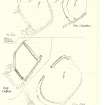
A dun occupies the highest point on the NE end of a rocky ridge, the site itself being isolated from the main mass of the ridge by a cleft which runs transversely across it.
The wall of the dun has been drawn round the margin of the summit, originally enclosing an area measuring about 30 by 15 metres. No signs of the wall are now visible on the north and east sides, but on the south and west, a band of stones up to 6 metres wide and standing to a height of 1.4 metres externally and 1 metre internally represents the remains of the wall on those sides. In the centre of the west side, a gap in the wall debris probably indicates the original entrance. A ruined wall, of no great age, runs up the west flank. The interior of the dun is featureless.
RCAHMS 1975, visited May 1969.
As described. On either side of the entrance within the wall are two oval, stone-built structures, possibly huts.
Surveyed at 1:2500.
Visited by OS (RD), 22 November 1971.
Field Visit (8 July 1943)
This site was included within the RCAHMS Emergency Survey (1942-3), an unpublished rescue project. Site descriptions, organised by county, vary from short notes to lengthy and full descriptions and are available to view online with contemporary sketches and photographs. The original typescripts, manuscripts, notebooks and photographs can also be consulted in the RCAHMS Search Room.
Information from RCAHMS (GFG) 10 December 2014.
Note (2 December 2014 - 18 May 2016)
This small fortification is situated on the summit of a knoll that falls away steeply everywhere except the W, where it can be approached across relatively level ground. Oval on plan, it measures about 30m from N to S by 15m transversely (0.04ha) within a wall reduced on the S and W to a bank of rubble some 6m in thickness by up to 1.4m in height externally and 1m internally, and elsewhere apparently robbed entirely. The entrance is on the W, where an old dyke also mounts the flank of the knoll. The interior is featureless, but the OS noted the footings of two oval structures in the rubble of the wall to either side of the entrance.
Information from An Atlas of Hillforts of Great Britain and Ireland – 18 May 2016. Atlas of Hillforts SC2592

