
Kilmore, Serpent Mound


Burial Cairn (Bronze Age)
Site Name Kilmore, Serpent Mound
Classification Burial Cairn (Bronze Age)
Alternative Name(s) Dalnaneum; Dalineun
Canmore ID 22933
Site Number NM82NE 7
NGR NM 88011 26886
Datum OSGB36 - NGR
Permalink http://canmore.org.uk/site/22933


- Council Argyll And Bute
- Parish Kilmore And Kilbride
- Former Region Strathclyde
- Former District Argyll And Bute
- Former County Argyll
NM82NE 7 8801 2688.
(NM 8801 2688) Cairn (NR)
OS 1:10,000 map, (1977)
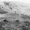
This round cairn, noted by Henshall (A S Henshall 1972) as an unclassified chambered cairn, has a diameter of about 19.7 metres and a height of 1.3 metres. It has been considerably disturbed by stone-robbing, and also by excavation undertaken by J S Phene in 1871 (A S Henshall 1972). In the centre, the excavation revealed a massively-built triangular cist containing a cremation deposit, a flint knife and some hazelnut shells which were probably modern. One stone of this cist can still be seen. It measures 0.8 metres in length by 0.3 metres in thickness and protrudes about 0.8 metres above the debris.
A S Henshall 1972, visited 1962; RCAHMS 1975, visited June 1967.
This cairn, generally as described, measures 25 to 26 metres in diameter. The unsurveyable remains of the kerb can still be seen.
Visited by OS (R D) 8 September 1971.
Field Visit (June 1967)
NM82NE 7 880 268. This cairn is situated at the W end of the esker known locally as the 'Serpent Mound' and 120m SW of Dalineum (Listed by Henshall as an unclassified chambered cairn (ARG 46)). Circular on plan, it measures about 19.7m in diameter and 1.3m in height, but it has been considerably disturbed by stone-robbing and also by excavation undertaken in 1871. In the centre the excavation revealed a massively-built triangular cist containing a cremation deposit, a flint knife and some hazelnut shells, the last probably modern. One stone of this cist can still be seen; it measures 0.8m in length by 0.3m in thickness and protrudes about 0.8m above the debris.
RCAHMS 1975, visited June 1967.
Watching Brief (February 2010 - July 2010)
Watching briefs were kept in February and July 2010 during the excavation of trenches at several locations along a power line around Loch Feochan to the S of Oban, during work related to its refurbishment. Replacement pole trenches were located at NM 86210 27458, NM 87711 27393, NM 88061 26987, NM 88302 24777, NM 89093 24659, NM 89315 24359 and NM 85714 25710. A stay trench was excavated at NM 88064 26938 and a cable trench dug between the pole at NM 88061 26987 and a house at NM 88056 26975. The overhead line was replaced by an underground one between NM 83012 23301 and NM 82968 23223.
Nothing of archaeological significance was found in any of the trenches.
Archive and report: RCAHMS and WoSAS
Funder: Scottish and Southern Energy plc
John Lewis – Scotia Archaeology

