
Rousay, Knowe Of Lingro


Chambered Cairn (Neolithic)
Site Name Rousay, Knowe Of Lingro
Classification Chambered Cairn (Neolithic)
Canmore ID 2289
Site Number HY33SE 22
NGR HY 39648 32378
Datum OSGB36 - NGR
Permalink http://canmore.org.uk/site/2289


- Council Orkney Islands
- Parish Rousay And Egilsay
- Former Region Orkney Islands Area
- Former District Orkney
- Former County Orkney
HY33SE 22 3964 3238.
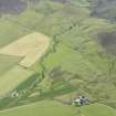
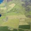
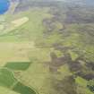
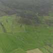
(HY 396 324 ) "Knowe of Lingro", an Orkney- Cromarty stalled cairn lies on the hillside on a sloping field.
A S Henshall 1963.
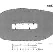
The turf-covered mound is rectangular in plan with rounded corners, measuring 70 ft E-W and 40 ft N-S, and about 5 ft high. It has a well-defined edge, but this is greater in extent than the construction it covers, for what appears to be a short length of the wall facing of the cairn is exposed 5 ft within the edge on the S side.
The top of the mound has been removed and a number of upright slabs are just exposed in the centre. These slabs are aligned at right angles to the main axis and are evidently the divisional slabs of a stalled chamber. Five stones can be seen on the N side of the chamber and three on the S side. The paved stones are set 3 ft apart and the compartments seem to be about 5 ft long. A short length of the N wall-face of the chamber can be seen in the centre of the N side. Neither end of the chamber is exposed and it is presumably considerably longer than the
22 ft indicated at present.
RCAHMS 1946. Visited 1934.
'Knowe of Lingro' at HY 3964 3238, as described and planned by Henshall.
Re-surveyed at 1/2500
Visited by OS(AA) 12 October 1972.
Field Visit (1941)
Visited by Childe in 1941.
V G Childe 1942
Orkney Smr Note (September 1980)
Oval mound 66 x 39ft, 5 ft high, turfed, many stones
exposed. On crest, 4 slabs on end show 1ft above surface; they
are in pairs at a distance of 16ft apart, the members of each
pair 3ft apart. Suggests a chambered cairn. [R1]
Turfed mound, rectangular, with rounded corners, 70ft E-W x
40ft x 5ft high, has a well defined edge but this is greater in
extent than the construction it covers, for what appears to be a
short length of facing wall is exposed 5ft within edge on S side.
Top of mound has been removed and some upright slabs exposed in
centre. These slabs are aligned at right angles to main axis and
are evidently stall-slabs. 5 stones on N side, 3 on S. Short
length of N wall-face of chamber visible. [R2]
As described Henshall. OS visit Oct 72.
As described.
Information from Orkney SMR (RGL) Sep 80.
Field Visit (September 1980)
Lingro (ORK 29) HY 3964 3238 HY33SE 22
Oval mound; surface indications suggest a stalled cairn.
RCAHMS 1982, visited September 1980
(RCAHMS 1946, ii, p. 203, No: 562; Henshall 1963, 212; OR 608)

