
Loch An Daimh


Crannog (Period Unassigned)(Possible), Island Dwelling(S) (Medieval)
Site Name Loch An Daimh
Classification Crannog (Period Unassigned)(Possible), Island Dwelling(S) (Medieval)
Canmore ID 22870
Site Number NM81SE 2
NGR NM 8618 1102
Datum OSGB36 - NGR
Permalink http://canmore.org.uk/site/22870


- Council Argyll And Bute
- Parish Craignish
- Former Region Strathclyde
- Former District Argyll And Bute
- Former County Argyll
NM81SE 2 8618 1102
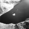
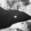
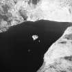
NM 8618 1102. Viewed from the shore, the larger and more northerly of the islands in Loch an Daimh - 'Loch of the Oxen' - shows evidence of an encircling wall and of two oblong houses.
M Campbell and M Sandeman 1964
NM 8618 1102. There is no boat on this loch. The remains on the island appear to be as described. No further information could be obtained locally.
Visited by OS (R D) 1 December 1969
The island appears on OS 1:10 000 map, (1974), but is neither named nor annotated.
One unroofed building, orientated SW-NE, is depicted on the 1st edition of the OS 6-inch map (Argyllshire 1875, sheet cxxx). One unroofed building, orientated NW-SE, is shown on the current edition of the OS 1:10000 map (1974).
Information from RCAHMS (SAH) 28 September 1998
Field Visit (May 1984)
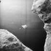
This small island is situated about 50m from the E shore of a remote loch at a height of 250m OD. Although surrounded by hills, it enjoys convenient access to the former township of Grianaig at the head of Gleann Domhain. The island measures about 17m from NE to SW and varies in width from12m in the NE half to 16m at the SW end. Its perimeter is revetted with boulders of medium size, and the surface rises to 1.5m above the normal level of the loch. A ridge of rock rises above water-level some 50m to the S, and the island was probably raised artificially on a continuation of the same ridge; indeed, some bedrock is visible at the S angle.
A transverse passage extending NNW from a small boat-inlet separates two subrectangular buildings (A, B on fig.) whose drystone walls stand in places to a height of 1m. They measure respectively 10.8m and 8.4m from NNW to SSE by 5.6m and 4.9m transversely, and the smaller (B) has an annexe attached to its SSE end-wall, while the inner face of the NNW end of its ENE wall is cut back to form a possible bed-recess.
Although few features are visible because of the growth of thick grass, these remains appear to be of late-medieval or 16th-century type, and a residence on 'L(och) Kendaif' is shown on Pont's map of Lorn, based on a survey of late 16th century date (en.1). No other documentary references to the site have been identified, but it was probably attached to the township of Grianaig, which from the 14th to the early 17th century belonged to the Maclver Campbells of Lergychonie and Asknish (en.2). A 19th-century tradition affirmed that it was used as a refuge by the Campbells of Asknish during Alasdair MacDonald's campaigns in Argyll in the 1640 (en.3).
RCAHMS 1992, visited May 1984
Measured Survey (1984)
RCAHMS surveyed Loch an Daimh island-dwelling in 1984 with plane-table and alidade producing a site plan at a scale of 1:400. The plan was redrawn in ink and published at a scale of 1:1000 (RCAHMS 1992, 305A).

