 |
On-line Digital Images |
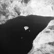
SC 1861001 |
RCAHMS Aerial Photography |
Oblique aerial view centred on the remains of the possible crannog and buildings, taken from the SE. |
22/11/2001 |
Item Level |
|
 |
On-line Digital Images |
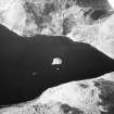
SC 1861002 |
RCAHMS Aerial Photography |
Oblique aerial view centred on the remains of the possible crannog and buildings, taken from the SE. |
22/11/2001 |
Item Level |
|
 |
On-line Digital Images |
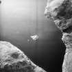
SC 1861003 |
RCAHMS Aerial Photography |
Oblique aerial view centred on the remains of the possible crannog and buildings, taken from the NE. |
22/11/2001 |
Item Level |
|
 |
On-line Digital Images |
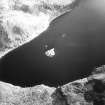
SC 1861004 |
RCAHMS Aerial Photography |
Oblique aerial view centred on the remains of the possible crannog and buildings, taken from the NNW. |
22/11/2001 |
Item Level |
|
 |
On-line Digital Images |
SC 2384278 |
Records of the Ordnance Survey, Southampton, Hampshire, England |
Loch An Daimh, NM81SE 2, Ordnance Survey index card, page number 1, Recto |
1958 |
Item Level |
|


