
Allt Bealaich Ruaidh


Cup And Ring Marked Rock (Prehistoric)
Site Name Allt Bealaich Ruaidh
Classification Cup And Ring Marked Rock (Prehistoric)
Alternative Name(s) A' Chruach
Canmore ID 22812
Site Number NM80SE 51
NGR NM 89467 00734
Datum OSGB36 - NGR
Permalink http://canmore.org.uk/site/22812


- Council Argyll And Bute
- Parish Kilmichael Glassary
- Former Region Strathclyde
- Former District Argyll And Bute
- Former County Argyll
Field Visit (April 1984)
NM80SE 51 8947 0077.
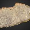
This cup-and-ring marked rock-sheet is situated in broken moorland about 1.2km SE of Glasvaar farmhouse; it lies about 50m NE of a forestry plantation and overlooks the N bank of the Allt Bealaich Ruaidh. The gently sloping rock surface has weathered decoration comprising: two cups with two rings and gutters (190mm overall); one cup and two rings (170mm overall); four cups with single rings (up to 115mm overall); and at least four plain cups (up to 60mm by 10mm).
RCAHMS 1988, visited April 1984
(M Campbell 1981)
Note (8 June 2018)
Date Fieldwork Started: 08/06/2018
Compiled by: Parallel Grooves
Location Notes: Allt Bealaich Ruaidh is located in open moorland, also used for grazing sheep, close to the end of a track that passes through the forestry plantation to the W/SW. The panel is situated on a small cliff to the E of where the Allt Bealaich Ruaidh stream meets a stone field wall. Approximately 8 m to the SW of the panel there is a stone field wall which runs SE-NW. The most easterly corner of the plantation is a short distance W of the panel, and Glasvaar farmhouse is 1.24 km to the NW.
Panel Notes: Allt Bealaich Ruaidh consists of a long, narrow, rectangular outcropping rock sheet measuring 11.5 m by 1.3 m (carved surface measures 4.5 m), which slopes approximately 8 degrees to the SE. The panel surface is smooth and hard with coarse grain size, and has fissures/cracks and natural hollows. Turf covers the edges of the panel, and easily-removable moss grows over much of its surface. The panel features 10 cup marks, 4 of which may have rings, 3 cups with 1 ring, 1 cup with 2 rings, 4 teardrop-shaped keyholes with 1 arc, and 2 teardrop-shaped keyholes with 2 arcs. Rock type identified using online information from the British Geological Survey.

