
Rousay, Quandale, Knowe Of Dale


Burnt Mound (Bronze Age)
Site Name Rousay, Quandale, Knowe Of Dale
Classification Burnt Mound (Bronze Age)
Alternative Name(s) Quendal
Canmore ID 2280
Site Number HY33SE 15
NGR HY 3742 3217
Datum OSGB36 - NGR
Permalink http://canmore.org.uk/site/2280


- Council Orkney Islands
- Parish Rousay And Egilsay
- Former Region Orkney Islands Area
- Former District Orkney
- Former County Orkney
HY33SE 15 3742 3217.
(HY 3741 3217) Knowe of Dale (NR).
OS 6"map, Orkney, 2nd ed.,(1900).
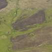
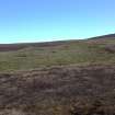
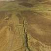
"Knowe of Dale". A completely grass-covered mound, of which a considerable portion of the SW side has been removed, standing in formerly cultivated ground now given over to pasture. It measures approx 70 ft NW-SE by 60 ft NE-SW and varies in height from about 4ft 6 ins at the NW to 7ft 6 ins at the SE.
An excavation made by the proprietor, Mr W G Grant, established the presence of burnt material and part of a slab-built box c.5ft by c.4ft. RCAHMS 1946. Visited 1928.
"Knowe of Dale", a crecentic burnt mound, open to the W with the partly exposed slab-built box visible near the centre.
Surveyed at 1:10 000.
Visited by OS(AA) 11 October 1972.
Desk Based Assessment (23 February 1971)
(HY 3741 3217) Knowe of Dale (NR).
OS 6"map, Orkney, 2nd ed.,(1900).
"Knowe of Dale". A completely grass-covered mound, of which a considerable portion of the SW side has been removed, standing in formerly cultivated ground now given over to pasture. It measures approx 70 ft NW-SE by 60 ft NE-SW and varies in height from about 4ft 6 ins at the NW to 7ft 6 ins at the SE.
An excavation made by the proprietor, Mr W G Grant, established the presence of burnt material and part of a slab-built box c.5ft by c.4ft.
Scheduled.
Information from OS 23 February 1971.
Source: RCAHMS 1946. Visited 1928; AMs Scot 1967, 32.
Field Visit (11 October 1972)
"Knowe of Dale", a crecentic burnt mound, open to the W with the partly exposed slab-built box visible near the centre.
Surveyed at 1:10 000.
Visited by OS(AA) 11 October 1972.
Orkney Smr Note (October 1972)
On formerly cultivated grount, now pasture. Mound grassed
and much of it removed on SW side. Remains of cist-like
construction protruding through turf in the hollow. Mound 70ft
NW-SE x 60 ft, height 4ft 6in at NW, 7ft 6in at SE. Excavated by
W G Grant after RCAMS visit, he found burnt material and a
slab-formed box 5ft long x 4ft wide. [R1]
Crescentic burnt mound open to W, the partly-exposed
slab-formed box visible near centre. OS visit October 1972.
Field Visit (September 1979)
Knowe of Dale HY 3741 3217 HY33SE 15
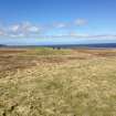
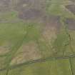
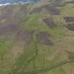
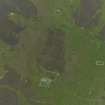
This impressive burnt mound is situated 400m SSE of Tofts (HY33SE) and about 100m S of the Burn of Tofts; crescentic on plan, with the open end to the W, the mound measures about 21m from NW to SE and 18m transversely and stands to a maximum height of 2.3m. It was partly excavated by Grant, who revealed a rectangular stone setting (1.5m by 1.2m), which is still visible.
RCAHMS 1982, visited September 1979
(RCAHMS 1946, ii, p. 225, No. 584; OR 469)
Field Visit (September 1979)
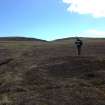
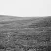
As described. Slab-structure still visible. Mound is
grassed, rabbit-scrapes show only peat.
Information from Orkney SMR (RGL) September 1979.
Field Visit (25 October 2007 - 13 November 2007)
HY 37300 32500 (centred on) A walkover survey covering c275ha took place 25 October–13 November 2007. A total of 138 sites, ranging from Bronze Age burnt mounds and a possible Bronze Age settlement to post-medieval standing buildings, feelie dyke enclosures and kail yards were identified. These include 111 new sites not listed by the RCAHMS.
Rather than being confined to description, this MSc dissertation discusses the landscape of Quandale at an
interpretive level. The aim was to attempt to break down period boundaries and use the same theoretical approach to the prehistoric and historical sites in the field and in later analysis and discussion.
Significant aspects of the earlier landscape include the close relationship between the Bronze Age barrow cemetery, burnt mounds and possible Late Bronze Age dyke in the S part of the study area. These monuments endure and take on new meaning in the later historical landscape. This is demonstrated by the appropriation of some Bronze Age barrows by certain crofts, a practice which is bound up in certain folklore beliefs. Several burnt mounds to the N fell within a large enclosure associated with the 16th-century house of Tafts (HY33SE 44). However, the large burnt mound, the Knowe of Dale (HY33SE 15), is not enclosed. It appears that while some burnt mounds were included, others were excluded from infield enclosures. The later landscape is considered in terms of the tasks of daily life, including the construction of post-medieval earth and stone dykes and aspects of tenure and folklore. Social stratification was reflected in the structures of everyday life and gender in these crofting communities. Quandale is not a relict landscape but a dynamic one with a future.
Dissertation: Orkney SMR, Orkney Library and RCAHMS (intended)
Daniel Lee (Orkney College), 2008
Geochemical Survey (March 2011)
HY 37410 32205 A gradiometer survey covering c3ha was undertaken in March 2011 over four key areas within the Quandale landscape. The sites included a potential prehistoric settlement, an area around a 16th-century house (Tafts) including out-buildings and associated enclosures, a burnt mound at Knowe of Dale (HY33SE 15) and two small burnt mounds close to a barrow cemetery (HY33SE 26). The aim of the survey was to place these monuments within the context of the surrounding landscape. The results were mixed with weak responses from the prehistoric settlement and extensive rig and furrow around the 16th-century house. More positive responses were recorded for the burnt mounds, although an extant earthwork gave very little magnetic response.
Archive: ORCA Geophysics
Funder: Orkney Island Council
ORCA Geophysics, 2011

