 |
On-line Digital Images |
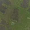
DP 056426 |
RCAHMS Aerial Photography Digital |
Oblique aerial view centred on the remains of the farmsteads, field systems and head dykes, taken from the WNW. |
24/9/2008 |
Item Level |
|
 |
On-line Digital Images |
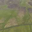
DP 059748 |
RCAHMS Aerial Photography Digital |
Oblique aerial view centred on the remains of the farmsteads, rig, field systmes and burnt mound at Quendal, taken from the SE. |
12/5/2009 |
Item Level |
|
 |
On-line Digital Images |
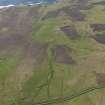
DP 059749 |
RCAHMS Aerial Photography Digital |
Oblique aerial view centred on the remains of the farmsteads, rig, field systmes and burnt mound at Quendall, taken from the SE. |
12/5/2009 |
Item Level |
|
 |
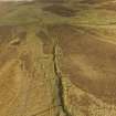
On-line Digital Images |
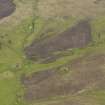
DP 060189 |
RCAHMS Aerial Photography Digital |
Oblique aerial view centred on the Knowe of Dale burnt mound, taken from the W. |
13/5/2009 |
Item Level |
|
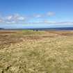 |
On-line Digital Images |
DP 153283 |
RCAHMS Field Survey Digital Photography |
General shot of burnt mound. |
9/5/2013 |
Item Level |
|
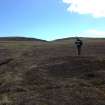 |
On-line Digital Images |
DP 153302 |
RCAHMS Field Survey Digital Photography |
General shot of new burnt being surveyed, with Knowe of Dale behind. |
9/5/2013 |
Item Level |
|
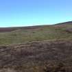 |
On-line Digital Images |
DP 153303 |
RCAHMS Field Survey Digital Photography |
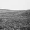
General shot of the Knowe of Dale, Rousay. |
9/5/2013 |
Item Level |
|
 |
On-line Digital Images |
DP 214600 |
Papers of Dr George F Geddes, archaeologist, Edinburgh, Scotland |
Oblique aerial view of the farmsteads and burnt mound in Quandale, looking NNW. |
5/2015 |
Item Level |
|
 |
On-line Digital Images |
SC 1923330 |
Papers of Dr Raymond G Lamb, archaeologist, Keith, Moray, Scotland |
R.Lamb |
1979 |
Item Level |
|
 |
On-line Digital Images |
SC 2341185 |
Records of the Ordnance Survey, Southampton, Hampshire, England |
Rousay, Quandale, Knowe Of Dale, HY33SE 15, Ordnance Survey index card, Recto |
1958 |
Item Level |
|
 |
On-line Digital Images |
SC 2341186 |
Records of the Ordnance Survey, Southampton, Hampshire, England |
Rousay, Quandale, Knowe Of Dale, HY33SE 15, Ordnance Survey index card, Recto |
1958 |
Item Level |
|


