|
Manuscripts |
MS 229/13 |
Records of the Royal Commission on the Ancient and Historical Monuments of Scotland (RCAHMS), Edinbu |
Burnt mound at Knowe of Dale, Rousay. |
10/1936 |
Item Level |
|
|
Photographs and Off-line Digital Images |
O 2120 |
Papers of Dr Raymond G Lamb, archaeologist, Keith, Moray, Scotland |
R.Lamb |
1979 |
Item Level |
|
|
Prints and Drawings |
ORD 7/3 |
|
Map of parish of Rousay, showing burial mounds at Quadrangle. |
1935 |
Item Level |
|
 |
On-line Digital Images |
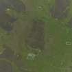
DP 056426 |
RCAHMS Aerial Photography Digital |
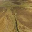
Oblique aerial view centred on the remains of the farmsteads, field systems and head dykes, taken from the WNW. |
24/9/2008 |
Item Level |
|
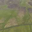 |
On-line Digital Images |
DP 059748 |
RCAHMS Aerial Photography Digital |
Oblique aerial view centred on the remains of the farmsteads, rig, field systmes and burnt mound at Quendal, taken from the SE. |
12/5/2009 |
Item Level |
|
 |
On-line Digital Images |
DP 059749 |
RCAHMS Aerial Photography Digital |
Oblique aerial view centred on the remains of the farmsteads, rig, field systmes and burnt mound at Quendall, taken from the SE. |
12/5/2009 |
Item Level |
|
 |
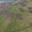
On-line Digital Images |
DP 060189 |
RCAHMS Aerial Photography Digital |
Oblique aerial view centred on the Knowe of Dale burnt mound, taken from the W. |
13/5/2009 |
Item Level |
|
 |
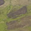
On-line Digital Images |
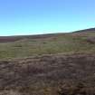
DP 153283 |
RCAHMS Field Survey Digital Photography |
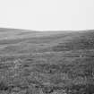
General shot of burnt mound. |
9/5/2013 |
Item Level |
|
 |
On-line Digital Images |
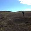
DP 153302 |
RCAHMS Field Survey Digital Photography |
General shot of new burnt being surveyed, with Knowe of Dale behind. |
9/5/2013 |
Item Level |
|
 |
On-line Digital Images |
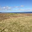
DP 153303 |
RCAHMS Field Survey Digital Photography |
General shot of the Knowe of Dale, Rousay. |
9/5/2013 |
Item Level |
|
|
Manuscripts |
MS 7280 |
Orkney Research Centre for Archaeology (ORCA) |
Report: 'Geophysical Survey Report, Quandale, Rousay.' |
3/2010 |
Item Level |
|
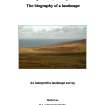 |
Digital Files (Non-image) |
WP 003544 |
General Collection |
Daniel Lee: Masters Dissertation - Quandale, Rousay: the biography of a landscape. PDF copy. |
2008 |
Item Level |
|
 |
On-line Digital Images |
DP 214600 |
Papers of Dr George F Geddes, archaeologist, Edinburgh, Scotland |
Oblique aerial view of the farmsteads and burnt mound in Quandale, looking NNW. |
5/2015 |
Item Level |
|
 |
On-line Digital Images |
SC 1923330 |
Papers of Dr Raymond G Lamb, archaeologist, Keith, Moray, Scotland |
R.Lamb |
1979 |
Item Level |
|
 |
On-line Digital Images |
SC 2341185 |
Records of the Ordnance Survey, Southampton, Hampshire, England |
Rousay, Quandale, Knowe Of Dale, HY33SE 15, Ordnance Survey index card, Recto |
1958 |
Item Level |
|
 |
On-line Digital Images |
SC 2341186 |
Records of the Ordnance Survey, Southampton, Hampshire, England |
Rousay, Quandale, Knowe Of Dale, HY33SE 15, Ordnance Survey index card, Recto |
1958 |
Item Level |
|
|
All Other |
551 166/1/1 |
Records of the Ordnance Survey, Southampton, Hampshire, England |
Archaeological site card index ('495' cards) |
1947 |
Sub-Group Level |
|


