|
Manuscripts |
MS 2275 |
|
The Argyll Crannog Survey 2003 by M Graeme Cavers, University of Nottingham. |
2003 |
Item Level |
|
 |
On-line Digital Images |
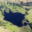
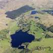
DP 112034 |
RCAHMS Aerial Photography Digital |
General oblique aerial view of Loch Ederline, taken from the SW. |
2/5/2011 |
Item Level |
|
 |
On-line Digital Images |
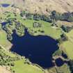
DP 112035 |
RCAHMS Aerial Photography Digital |
General oblique aerial view of Loch Ederline, taken from the SW. |
2/5/2011 |
Item Level |
|
 |
On-line Digital Images |
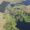
DP 112036 |
RCAHMS Aerial Photography Digital |
General oblique aerial view of Ford with Loch Ederline adjacent, taken from the SW. |
2/5/2011 |
Item Level |
|
 |
On-line Digital Images |
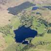
DP 112038 |
RCAHMS Aerial Photography Digital |
General oblique aerial view of Loch Ederline, taken from the SSW. |
2/5/2011 |
Item Level |
|
 |
On-line Digital Images |
DP 112039 |
RCAHMS Aerial Photography Digital |
General oblique aerial view of Loch Ederline, taken from the S. |
2/5/2011 |
Item Level |
|
 |
On-line Digital Images |
SC 2384076 |
Records of the Ordnance Survey, Southampton, Hampshire, England |
Loch Ederline, NM80SE 39, Ordnance Survey index card, Recto |
1958 |
Item Level |
|
 |
On-line Digital Images |
SC 2384077 |
Records of the Ordnance Survey, Southampton, Hampshire, England |
Loch Ederline, NM80SE 39, Ordnance Survey index card, Recto |
1958 |
Item Level |
|
 |
On-line Digital Images |
SC 2384078 |
Records of the Ordnance Survey, Southampton, Hampshire, England |
Loch Ederline, NM80SE 39, Ordnance Survey index card, Recto |
1958 |
Item Level |
|
|
All Other |
551 166/1/1 |
Records of the Ordnance Survey, Southampton, Hampshire, England |
Archaeological site card index ('495' cards) |
1947 |
Sub-Group Level |
|


