
Glasvaar 2


Cup Marked Stone (Neolithic) - (Bronze Age)
Site Name Glasvaar 2
Classification Cup Marked Stone (Neolithic) - (Bronze Age)
Canmore ID 22792
Site Number NM80SE 33
NGR NM 88264 01346
Datum OSGB36 - NGR
Permalink http://canmore.org.uk/site/22792


- Council Argyll And Bute
- Parish Kilmichael Glassary
- Former Region Strathclyde
- Former District Argyll And Bute
- Former County Argyll
NM80SE 33 8826 0135.
(NM 8826 0135) Cup marked Rock (NR)
OS 1:10,000 map, (1975)
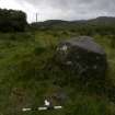
A cup marked boulder, known locally as "The Covenanter's Communion Table", stands on the west edge of an arable terrace on the north side of the approach road to Glasvaar farm, at a small quarry. The boulder measures 5' by 3' by 1' 6" and has at least 20 cups, the largest of which is 3" in diameter and 1" deep. There is a row of five cups along the axis of the stone.
M Campbell and M Sandeman 1964.
As described. Name not confirmed locally.
Surveyed at 1:2500 scale.
Visited by OS (D W R) 8 December 1971.
Prominent boulder 2m by 1.5m by 0.75m with smooth top sloping 5 degrees N, on which are three cups-and-one-ring, all gapped or incomplete and up to 19cm diameter; also at least twelve cups. All much weathered. Maxiumum depth of carvings 2cm. Situated 55m NE of point where road crosses a burn.
R Morris 1982
NM 882 013. There are at least fifteen plain cupmarks measuring up to 90mm by 30mm on the level top of a prominent erratic boulder which lies in a field about 200m SW of Glasvaar farmhouse (see also NM80SE 51).2 Immediately to the NE three other cupmarks are visible on the outcrop on which the boulder rests.
Visited May 1984
RCAHMS 1988
Field Visit (May 1984)
NM 882 013. There are at least fifteen plain cupmarks measuring up to 90mm by 30mm on the level top of a prominent erratic boulder which lies in a field about 200m SW of Glasvaar farmhouse (Campbell and Sandeman 1964, no. 232; DES 1959, 6; DES 1981, 28). Immediately to the NE three other cupmarks are visible on the outcrop on which the boulder rests.
Visited May 1984
RCAHMS 1988
Note (31 July 2018)
Date Fieldwork Started: 31/07/2018
Compiled by: Parallel Grooves
Location Notes: Glasvaar 2 is a prominent glacial erratic boulder on a hillside terrace approximately 200m NW of Glasvaar farm, 20m W of the track leading to the main farmhouse and uphill from Glasvaar Cottage. There are views over the valley to the W, and the panel lies down the slope from a burial cairn as noted on OS maps (Canmore ID 22799). The panel is situated in a field used for animal grazing, in otherwise sloping terrain. Glasvaar 3 is situated immediately to the NE at the boulder's base. There are various other loose boulders around the base of Glasvaar 2, suggesting that it may form part of a delapidated burial or field clearance cairn.
Panel Notes: This panel comprises a prominent rounded glacial erratic, measuring 1.5 by 0.9 metres with the highest point extending 0.7 metres above ground level. The carved surface is largely free of moss cover, and is flat with a slight slope (4 degrees) to the NE. Motifs include 16 cupmarks, which vary in size, some of which are positioned along the longer axis of the boulder. There are an additional 6 potential shallow cupmarks.

