
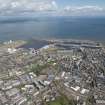
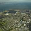
Edinburgh, Leith Docks, Western Harbour


Harbour (Period Unassigned)
Site Name Edinburgh, Leith Docks, Western Harbour
Classification Harbour (Period Unassigned)
Alternative Name(s) Hmry Britannia; Firth Of Forth; Outer Forth Estuary
Canmore ID 227648
Site Number NT27NE 57.10
NGR NT 2650 7750
Datum OSGB36 - NGR
Permalink http://canmore.org.uk/site/227648


- Council Edinburgh, City Of
- Parish Edinburgh (Edinburgh, City Of)
- Former Region Lothian
- Former District City Of Edinburgh
- Former County Midlothian
NT27NE 57.10 2650 7750
For Caledonia Flour Mills (Chancelot Mill) at NT 26016 77051, see NT27NE 117.
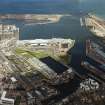
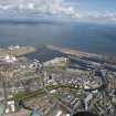
Western Harbour [NAT] (centred NT 2624 7739)
OS 1:10,000 map, 1985.
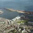
[1998 air photpographs] HMRY BRITANNIA in interim berth with temporary visitor centre prior to transfer to permanent berth at Ocean Terminal.
(Undated) information in NMRS.
The location assigned to this record is essentially arbitrary. The Western Harbour was formed by the construction of the West and East Breakwaters (NT27NE 57.07 and NT27NE 57.08 respectively) around the greater part of the perimeter of the former Leith Roads, which were themselves protected by the Martello Tower NT27NE 43. The Western Harbour remained tidal until the late 1960's, when the new entrance lock (NT27NE 57.03) and associated dam (NT27NE 57.45) were constructed at the N corner.
Information from RCAHMS (RJCM), 13 June 2006.

