
Lismore, An Dun, Sloc A' Bhrighide


Dun (Period Unassigned)
Site Name Lismore, An Dun, Sloc A' Bhrighide
Classification Dun (Period Unassigned)
Canmore ID 22658
Site Number NM73NE 3
NGR NM 7998 3651
Datum OSGB36 - NGR
Permalink http://canmore.org.uk/site/22658


- Council Argyll And Bute
- Parish Lismore And Appin (Argyll And Bute)
- Former Region Strathclyde
- Former District Argyll And Bute
- Former County Argyll
NM73NE 3 7998 3651.
(NM 7998 3651) An Dun (NR)
OS 1:10,000 map, (1976)
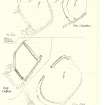
The remains of this dun occupy the tip of a rocky promontory, with sheer cliffs up to 10.7 metres high forming a natural defence on the NE and SE sides; but access on the NW is comparatively easy. Only intermittent traces of the dun wall remain, appearing mainly as bands of stony debris enclosing as area measuring 23 by 20 metres. Although no inner facing stones can now be seen, several portions of the outer face survive, the best preserved section, on the SSE, standing to a height of 1.4 metres, with the lowest course set 3 metres below the level of the interior. At one point on the West side two separate, overlapping stretches of facing stones can be seen, the inner stretch being set back about 1 metre and some 1.2 metres above the other, probably to give an internal revetment for extra stability due to the steep- ness at that point.
The entrance is on the NW. In the interior of the dun, at a short distance from the entrance, there is an isolated spread of stony debris with three earthfast boulders ranged in a straight line along its NW edge. If contemporary with the dun, this would be a very unusual structure, presumably intended to provide protection for the entrance from the inside. However, it may be a secondary feature, as much of the interior of the dun has been under cultivation at some time. Remains of a comparatively recent stone wall can be seen overlying the dun wall between the entrance and the cliff edge on the north.
RCAHMS 1975, visited May 1968.
As described.
Surveyed at 1:10 000.
Visited by OS (RD) 9 November 1971.
Field Visit (7 July 1943)
This site was included within the RCAHMS Emergency Survey (1942-3), an unpublished rescue project. Site descriptions, organised by county, vary from short notes to lengthy and full descriptions and are available to view online with contemporary sketches and photographs. The original typescripts, manuscripts, notebooks and photographs can also be consulted in the RCAHMS Search Room.
Information from RCAHMS (GFG) 10 December 2014.

