
Leccamore, Luing


Cup Marked Stone (Neolithic) - (Bronze Age), Galleried Dun (Prehistoric)
Site Name Leccamore, Luing
Classification Cup Marked Stone (Neolithic) - (Bronze Age), Galleried Dun (Prehistoric)
Canmore ID 22629
Site Number NM71SE 2
NGR NM 75075 10784
Datum OSGB36 - NGR
Permalink http://canmore.org.uk/site/22629


- Council Argyll And Bute
- Parish Kilbrandon And Kilchattan
- Former Region Strathclyde
- Former District Argyll And Bute
- Former County Argyll
NM71SE 2 7507 1078.
(NM 7507 1078) Dun (NR)
OS 1:10,000 map, (1976)
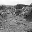
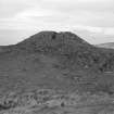
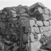
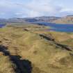
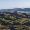
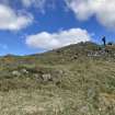
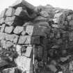
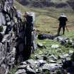
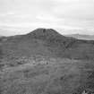
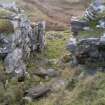
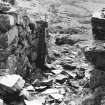
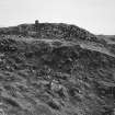
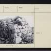
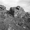
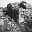
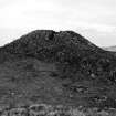
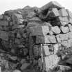
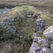
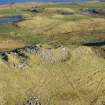
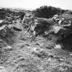
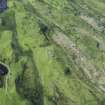
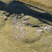
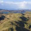
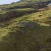
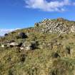
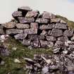
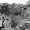
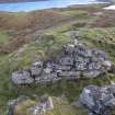
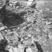
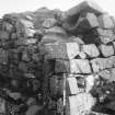
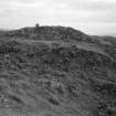
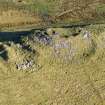
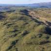
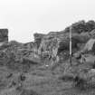
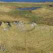
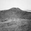
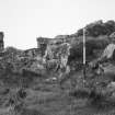
The impressive dun of Leccamore stands within outworks on the highest part of the easternmost of the dorsal ridges of Luing. The dun was partially excavated by Macnaugton in 1890 (1891) and 1892 (Macnaughton 1893). It measures 19.8 by 12.8 metres within a wall 4.0 metres to 4.9 metres thick, and has an entrance in the SW and another in the NE. Long stretches of both faces of the wall are visible throughout the circuit and at the south end where it is best preserved, the outer face stands to a height of 3 metres in eight well-laid courses.
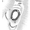
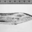
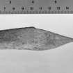
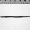
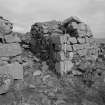
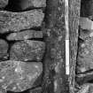
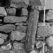
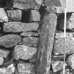
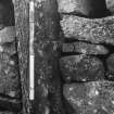
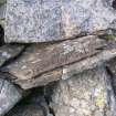
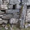
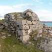
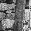
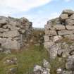
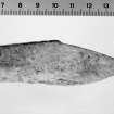
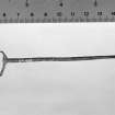
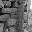
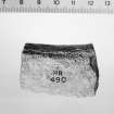
The SW entrance measures 1.7 metres in width externally, and to provide checking for a door, two jamb stones have been built about 1.2 metres inside the outer corners of the passage. The south jamb measures 1.32 metres in height, 0.43 metres in width and about 0.23 metres in thickness. The inner face of this stone has at least fifteen cup-marks pecked into it, ranging from 38mm to 76mm in diameter and between 13 and 25mm in depth. The north jamb is of a similar size to the one on the south. There is a bar hole 0.9 metres in depth on the north side of the passage, and on the south side there is a complementary slot for storing the bar, extending 2.7 metres into the thickness of the wall. The entrance passage, which was originally paved, is 4.3 metres in length, and the walls now stand to a height of 1.8 metres. The lintel over the door and some of the roof slabs of the passage had been removed only a short time before the excavation of 1890.
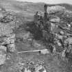
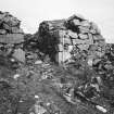
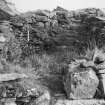
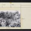
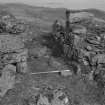
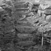
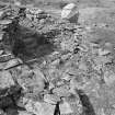
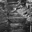
The NE entrance has a uniform width of 1.5 metres. There is no trace of door checks, but these may have been removed when the outer corners of the passage were destroyed. On the south side of the passage are the remains of a straight-sided chamber extending into the wall for a distance of 1.2 metres. On the north side, there is an oval guard chamber which is entered up a step and along a narrow passage. This chamber measures 2.7 by 2.4 metres and its walls stands to a height of 1.4 metres above the debris covering the floor of the chamber. A flight of steps leads from the chamber to the wall-head. The foundations of walled enclosures within the dun are clearly secondary.
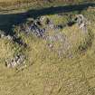
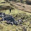
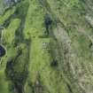
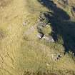
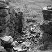
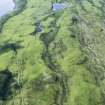
The steep, grassy flanks of the ridge give natural protection for the dun on the east, but additional defences have been provided on the other three sides. On the north, are two rock-cut ditches measuring 1.8 and 3 metres in depth respectively, while on the north, west and south there is an outer wall which largely follows the natural crest line. Considerable stretches of the outer face survive on the south and there are shorter stretches of outer and inner facing stones on the west and NW, but elsewhere the wall is reduced to a band of rubble. On the SW, a gap in line with the dun entrance probably indicates the site of a gateway.
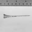
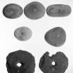
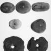
Finds from the excavations included stone implements, a bronze stem, a fragment of an iron blade, two bone points and a piece of worked antler, as well as a quantity of animal bones and shells. Most of the finds are in the National Museum of Antiquities of Scotland (NMAS).
A Macnaughton 1891; A Macnaughton 1893; RCAHMS 1975, visited May 1966.
As described.
Surveyed at 1:2500.
Visited by OS (DWR) 14 September 1971.
Field Visit (May 1966)
NM 750 107 Dun, Leccamore, Luing.
The impressive dun of Leccamore (Fig. 75) stands within outworks on the highest part of the easternmost of the dorsal ridges of Luing at a height of 85 m OD. Known also as 'An Caisteal' and the 'South Fort', it was partially excavated in 1890 and 1892 and the following account is based on the published reports (Macnaughton 1891; 1893).
The dun measures 19.8 m by 12.8 m within a wall from 4.0 m to 4.9 m in thickness, and has an entrance at either end. Long stretches of both faces of the wall are visible throughout the circuit, and at the S end, where it is best preserved, the outer face stands to a height of 3 m in eight well-laid courses with a batter of one in four. Many of the facing stones are massive blocks measuring up to 1'35 m by 0'46 m and about 0'38 m in thickness. The SW entrance (Pl. 11B) measures 1'7 m in width externally, and, in order to provide checking for a door, two jamb-stones have been built about 1'2 m inside the outer corners of the passage. The S jamb (Pl. 11C) is a slate slab measuring 1'32 m in height, 0'43 m in width and about 0'23 m in thickness; the inner face of this stone has at least fifteen cup-marks pecked into it, ranging between 38 mm and 76 mm in diameter and between 13 mm and 25 mm in depth. The N jamb is of similar size to the one on the S. There is a bar-hole 0'9 m in depth on the N side of the passage, and on the S side a complementary slot (PI. IIC) for storing the bar extends for 2'7 m into the thickness of the wall. The dimensions of these features indicate that the bar probably measured about 0'23 m by 0'18 m in section. The entrance-passage, which was originally paved, is 4'3 min total length and the walls now stand to a height of 1·8 m; after a slight expansion at the jambs, the passage narrows again to its original width. The lintel over the door, and some of the slabs forming the roof of the passage, had been removed only a short time before the excavation of 1890.
The second entrance, at the NE end of the dun, has a uniform width of 1.5 m at the present time. There is no trace of door-checks, but they may have been removed when the outer corners of the passage were destroyed. In the thickness of the wall on the S side of the passage there are the remains of a straight-sided chamber at a rather higher level than that of the present passage-floor. It extends into the wall for a distance of at least 1'2 m, but its original length is uncertain owing to the collapse of the inner end. On the N side there is an oval guard-chamber which is entered up a step (0'53 m high) and along a narrow passage. The chamber measures 2'7 m by 2'4 m; its walls, which are built of slate slabs, stand to a height of 1'4 m above the debris covering the floor of the chamber, and are corbelled inwards as they rise. A flight of steps (Pl. 11D) leads from the chamber to the wall-head, and slabs have also been used on one side of this stairway. On the NW there is a break in the inner face of the dun wall, but as it is choked with rubble and fallen stone it is uncertain whether or not this is a structural feature. The foundations of walled enclosures in the interior of the dun are clearly secondary.
The steep grassy flanks of the ridge, falling some 25m to marshy ground on either side, afford natural protection for the dun on the E, but additional defences have been provided on the other three sides. On the N two rock-cut ditches which, to judge by their width, may also have served the purpose of furnishing building material for the dun, have been drawn across the spine of the ridge. The outer ditch measures about 1·8 m in depth and the inner one about 3 m, while traces of walling can be seen on the scarp of the latter. On the N,W and S there is an outer wall which largely follows the natural crest-line; considerable stretches of the outer face survive on the S and there are shorter stretches of outer and inner facing-stones on the W and NW respectively, but elsewhere the wall is reduced to a band of rubble. On the SW a gap in line with the dun entrance presumably indicates the site of a gateway.
Most of the finds from the excavations are in the National Museum of Antiquities of Scotland, and a catalogue of the extant objects has recently been published (Ritchie 1974, 110); they include a number of stone implements, such as pounders, discs, querns and a quartzite strike-a-light. A thin bronze stem, a fragment of an iron blade, two bone points and a piece of worked antler were also found in the domestic refuse, as well as a quantity of animal bones and shells.
RCAHMS 1975, visited May 1966.
Measured Survey (May 1966)
RCAHMS surveyed this site by plane-table and alidade in May 1966 at a scale of 1mm:1ft. The resultant plan was redrawn in ink and published at a reduced size in RCAHMS 1975 as Figure 75.
Field Visit (14 September 1971)
As described.
Surveyed at 1:2500.
Visited by OS (DWR) 14 September 1971.
Publication Account (1985)
This dun is both remarkably well preserved and also contains several unusual features. Situated on the summit of a long ridge, it has been defended both by an outer wall and on the north by two rock-cut ditches which run athwart the ridge. The dun measures about 20m by 13m within a wall which is up to 5m in thickness. The dun has two apparently contemporary entrances, one on the south-west and the other on the north-east side. The outer wall-face on the south-west has been particularly carefully constructed with a distinct batter, and the walls of the entrance passage still stand to a height of almost 2m. The passage has door jambs close to the outside, one of the jamb-stones bearing at least fifteen cup-markings on one face; perhaps the stone was one slab of a cist burial discovered in the course of the original building work. The bar-hole and the opposing slot for storing the bar when the door was open are still visible, the slot extending for a distance of 2.7m into the thickness of the wall. The north-east entrance is less well preserved, but there are cells on both sides of the passage, that on the north-west side being carefully corbelled. Leading from the west side of this cell there is a flight of steps, which presumably allowed easy access to the wallhead in times of attack.
Information from ‘Exploring Scotland’s Heritage: Argyll and the Western Isles’, (1985).
Reference (1996)
NM 750 107 Leccamore, Dun, Luing
This dun is both remarkably well preserved and also contains several unusual features. Situated on the summit of a long ridge, it has been defended both by an outer wall and on the north by two rock-cut ditches which run athwart the ridge. The dun measures about 20 m by 13 m within a wall which is up to 5 m in thickness. The dun has two apparently contemporary entrances, one on the south-west and the other on the north-east side. The outer wall-face on the south-west has been particularly carefully constructed with a distinct batter, and the walls of the entrance passage still stand to a height of almost 2 m. The passage has door jambs close to the outside, one of the jamb-stones bearing at least fifteen cup-markings on one face; perhaps the stone was one slab of a cist burial discovered in the course of the original building work. The bar-hole and the opposing slot for storing the bar when the door was open are still visible, the slot extending for a distance of 2.7 m into the thickness of the wall. The north-east entrance is less well preserved, but there are cells on both sides of the passage, that on the north-west side being carefully corbel led. Leading from the west side of this cell there is a flight of steps, which presumably allowed easy access to the wall-head in times of attack.
RCAHMS 1996
Note (25 November 2014 - 18 May 2016)
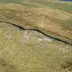
The spectacularly well-preserved dun on the summit of this ridge stands within a larger enclosure defended by a wall set lower down the slope. Irregular on plan, this enclosure measures about 50m from N to S by up to 40m transversely (0.13ha) within the wall, which is largely reduced to a band of rubble with a few runs of outer facing-stones on the S and W; a gap on the SW probably marks the entrance. On the N traces of a second wall can be seen on the inner lip of a ditch some 3m in depth, which, along with a second ditch 1.8m in depth, cuts across the spine of the ridge on this side. The dun itself measures about 20m from NNE to SSW by 13m transversely within a wall between 4m and 4.9m in thickness and still standing in some places up to 3m in height. One entrance with checks and a bar-hole lies on the SW, while a second with chambers to either side, that on the W leading to a mural stair, is on the NE. Excavations were carried out by Allan Macnaughton at the dun in 1890 and 1892.
Information from An Atlas of Hillforts of Great Britain and Ireland – 18 May 2016. Atlas of Hillforts SC2548
Note (20 June 2021)
Date Fieldwork Started: 20/06/2021
Compiled by: ACFA South Glasgow
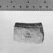
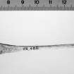
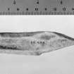
Location Notes: This stone presently forms a near vertical portal stone on the eastern jamb of the SW entrance to the dun. It has been removed from its original position. Evidence for this lies in that it is composed of slate but the country rock is metabasite, a form of metamorphosed volcanic rock. It is suspected that it may have been originally placed as an upright to the N of its present location where there may be a set of stones forming a possible socket support (NM 75235 11387).
Panel Notes: This is a thin, rectangular slate slab measuring 1.3m height x 0.3m width and 0.2m thick. It is in an upright position, leaning slightly to the N. There are up to 14 cupmarks on its outward facing surface.
Field Visit (30 March 2022)
NM71SE 2 75075 10784
The galleried dun at Leccamore has a panoramic view of the Sounds that flank Luing and is perhaps the most impressive of the island’s ancient monuments. It is much as previously described by the Ordnance Survey (1971) and RCAHMS (1975, No. 189), with the following observations focussed on the character and visibility of 19th century excavations. Antiquarian excavation has exposed many elements of the dun providing insights into architectural features such as the two entrances (one incorporating a reused cup-marked stone, a bar-hole and a door check), a staircase, a guard cell and outworks (compare with NR79SE 1, for example).
In a detailed examination of the dun in the 1880s, David Christison described how much of the site was ‘buried under a thick grass covering’ though his plan and notes make it clear that the SW entrance was visible at that time, as was the bar-hole in its SE jamb (1889, 406). Christison was accompanied on a ‘good many’ of his expeditions in Argyll by Allan Macnaughton of Taynuilt, and it was Macnaughton that opened Leccamore for examination. During a short holiday in 1890 he used workmen to ‘clear out the [SW] entrance’ (Macnaughton 1891, 478) and in 1892 he extended his exploration to the NE entrance (Macnaughton 1893).
The extent of the excavations, which involved ‘a waggon and several implements’ lent by local slate quarriers (1893, 380), are still evident on the ground and on visualisations derived from ALS data, as it seems little was done to return the monument to its previous state. Some of the excavation spoil takes up the NW of the interior, and a large cache of stones at the W end of the inner ditch is surely also related to his excavations. A band of rubble outside the SW entrance may also have been supplemented by excavation spoil, partially obscuring the line of an outer wall.
Visited by HES Archaeological Survey (G Geddes and D Bratt), 30 March 2022.

