 |
Digital Files (Non-image) |
WP 005079 |
Historic Environment Scotland |
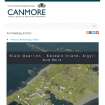
Digital copy of Archaeology InSites feature regarding Slate Quarries - Easdale Island, Argyll And Bute |
1/1/2017 |
Item Level |
|
|
Digital Files (Non-image) |
MV 000830 |
Historic Environment Scotland |
UAV video: Easdale Island and Slate Quarries |
5/10/2017 |
Item Level |
|
|
Digital Files (Non-image) |
MV 000831 |
Historic Environment Scotland |
UAV video: Easdale Island and Slate Quarries |
5/10/2017 |
Item Level |
|
|
Digital Files (Non-image) |
MV 000832 |
Historic Environment Scotland |
UAV video: Easdale Island and Slate Quarries |
5/10/2017 |
Item Level |
|
 |
Digital Files (Non-image) |
WP 007584 |
Records of the Royal Commission on the Ancient and Historical Monuments of Scotland (RCAHMS), Edinbu |
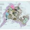
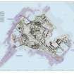
Layered interactive PDF of Easdale Island showing the mapping and phasing of the HES survey, quarrying activity, tipping, internal transport and garden enclosures. |
10/2019 |
Item Level |
|
 |
Digital Files (Non-image) |
WP 007585 |
Records of the Royal Commission on the Ancient and Historical Monuments of Scotland (RCAHMS), Edinbu |
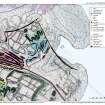
Layered interactive PDF map of north-east corner of Easdale Island showing HES survey, including North spoil, walls and workings. |
10/2019 |
Item Level |
|
 |
Digital Files (Non-image) |
WP 007586 |
Records of the Royal Commission on the Ancient and Historical Monuments of Scotland (RCAHMS), Edinbu |
Layered interactive PDF map of Easdale Island showing HES phasing survey |
10/2019 |
Item Level |
|
 |
Digital Files (Non-image) |
WP 007587 |
Records of the Royal Commission on the Ancient and Historical Monuments of Scotland (RCAHMS), Edinbu |
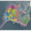
Layered interactive PDF map of Easdale Island showing HES survey of quarries, tramways and slate distribution. |
10/2019 |
Item Level |
|
|
Digital Files (Non-image) |
WP 007588 |
Records of the Royal Commission on the Ancient and Historical Monuments of Scotland (RCAHMS), Edinbu |
Layered interactive PDF map of south Easdale Island, Camus Mor area, showing HES survey of the south quarries including spoil, walls and workings. |
10/2019 |
Item Level |
|
 |
Digital Files (Non-image) |
WP 007589 |
Records of the Royal Commission on the Ancient and Historical Monuments of Scotland (RCAHMS), Edinbu |
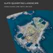
PDF report - Slate Quarrying Landscape, Easdale Island, Lorn, Argyll and Bute
|
5/2021 |
Item Level |
|
 |
Digital Files (Non-image) |
WP 008070 |
Historic Environment Scotland |
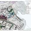
North east Easdale Survey Map: slate debris dumping and enclosures to west of Harbour area and to east to Windmill Quarry |
2018 |
Item Level |
|
 |
Digital Files (Non-image) |
WP 008073 |
Historic Environment Scotland |
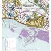
South west/ south central Easdale Survey Map: Klondyke Quarry to the north, agricultural enclosures (abandoned) and early coastal quarries to south |
2018 |
Item Level |
|


