
Seil, Clachan Bridge


Road Bridge (18th Century) (1791)
Site Name Seil, Clachan Bridge
Classification Road Bridge (18th Century) (1791)
Alternative Name(s) 'Bridge Over The Atlantic'; Clachan Sound; Seil Sound
Canmore ID 22603
Site Number NM71NE 22
NGR NM 78532 19693
Datum OSGB36 - NGR
Permalink http://canmore.org.uk/site/22603


- Council Argyll And Bute
- Parish Kilninver And Kilmelford
- Former Region Strathclyde
- Former District Argyll And Bute
- Former County Argyll
NM71NE 22 78532 19693
Clachan Bridge [NAT]
OS 1:10,000 map, 1978.
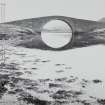
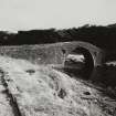
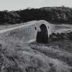
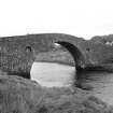
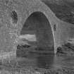
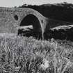
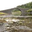
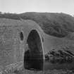
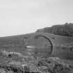
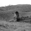
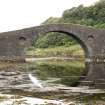
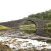
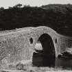
(Location cited as NM 785 197). Clachan Bridge, built 1792. A large segmental rubble bridge, with oculi in spandrels. Known as the 'bridge over the Atlantic'.
J R Hume 1977.
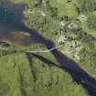
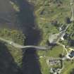
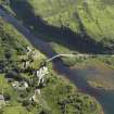
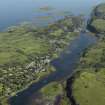
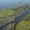
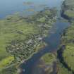
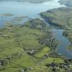
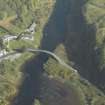
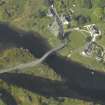
This bridge carries the B844 public road over Clachan Sound (a northern continuation of Seil Sound), and thus gives access from the mainland to the island of Seil (to the W). Clachan Sound here forms the boundary between the parishes of Kilbrandon and Kilchattan (to the W) and Kilninver and Kilmelfort (to the E).
Information from RCAHMS (RJCM), 17 May 2006.
Construction (1791 - 1792)
Built in 1791–92 of roughly coursed rubble with long thin slabs forming the
arch-rings.
R Paxton and J Shipway 2007b
Reproduced from 'Civil Engineering heritage: Scotland - Highlands asnd Islands' with kind permission of Thomas Telford Publishers.
Field Visit (June 1970)
Clachan Bridge, Seil. NM 785 196
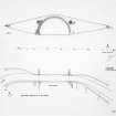
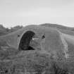
This bridge, which joins the island of Seil to the mainland, spans Clachan Sound at a point about 4.5 km SW of Kilninver. The bridge (Pl. 119B) crosses the narrow tidal channel by a single bold segmental arch having a span of 22 m and a height above high-water level of about 8.5 m. The overall length of the bridge with approaches is about 95 m, and the roadway measures 4.7 m in width between parapets 0.4 m in thickness. The masonry is of roughly-coursed boulder-rubble with copious pinnings, and the form of the arch is emphasised by long thin voussoir-slabs. Within the haunches of the arch there are circular recesses, 2.1 m in diameter; the central portion of the parapet is defined by small pyramidal blocks set above these recesses.
This site had been selected for a bridge as early as 1787, when it was identified as 'Intended Bridge' on an estate-plan by George Langlands (fn.1). In 1790 John Campbell of Lochend, Chamberlain of the Breadalbane estate in Argyll, rejected a suggestion that the channel should be filled in, and obtained a plan from John Stevenson, an Oban contractor, for a bridge having a main arch of 21 .3 m span, high enough to allow the passage of small vessels, together with a smaller arch of 6.1 m span. The greater part of the estimated cost of £450 was to be divided between Lord Breadalbane, the Easdale Slate Company, and MacDougall of Ardencaple. Lord Breadalbane suggested that a professional architect should be consulted, and it is probable that the design was amended by Robert Mylne (fn.2). The bridge was constructed in 1791 by John Stevenson, who made a considerable financial loss for which he received partial compensation from Lord Breadalbane in 1795 (fn.3).
RCAHMS 1975, visited June 1970
Footnotes.
1. S.R.O., RHP 975/1, Survey of Seil and Luing.
2. During the period when the design of Clachan Bridge was being discussed, Mylne was preparing plans for extensive works at Taymouth. In his diary for 13 April 1790 there appears the entry 'Gave Earl of Bread Albane ... a small drawing for the side of a Road Bridge' (Richardson, A E, Robert Mylne, Architect and Engineer, 1733 to 1811 (1955), 137). The Earl's intention of consulting an architect is acknowledged by John Campbell in a letter of 18 April 1790, before news of the meeting with Mylne could have reached him from London. It seems probable that Mylne suggested the omission of the smaller arch in Stevenson's original design, and included the decorative recesses which may be compared with those used at Hexham (ibid., pl. 42). There is no evidence to support the attribution of the bridge to Thomas Telford (made by, e.g., Gillies, Netherlorn, 35).
3. S.R.O., Breadalbane Collection, GD 112/48, Bridges Correspondence, 18 February, 18 April 1790; ibid., GD 112/9/3, Nether Lorn Rental, 1794-5.
Publication Account (2007)
Clachan Bridge is known as ‘the bridge over the Atlantic’ because it crosses a tiny arm of that ocean, namely the Clachan Sound, to join the Island of Seil to the mainland about 7 miles south-west of Oban.
The bridge is markedly humpbacked with an overall length of 300 ft and a single span masonry arch of 72 ft rising 27 ft above high water level and has a width between parapets of 15 ft. It was built in 1791–92 of roughly coursed rubble with long thin slabs forming the arch-rings. The central portion of the parapet is defined by small pyramidal blocks set above circular recesses 6 ft in diameter in the spandrels.
Before the bridge was built there was a suggestion in 1790 that the Sound be filled in, but this was rejected because of the passage required by fishing boats. The bridge, commissioned by the Earl of Breadalbane and others, was to the design of John Stevenson of Oban, revised by Robert Mylne. Stevenson was also the contractor. Attribution of the bridge to Telford by some writers and on some postcards is incorrect.
R Paxton and Jim Shipway 2007b
Reproduced from 'Civil Engineering heritage: Scotland - Highlands and Islands' with kind permission from Thomas Telford Publishers.

