
Craignish, Old Parish Church


Burial Ground (Medieval) - (Post Medieval), Church (Medieval), Font (Medieval), Grave Slab(S) (Medieval)
Site Name Craignish, Old Parish Church
Classification Burial Ground (Medieval) - (Post Medieval), Church (Medieval), Font (Medieval), Grave Slab(S) (Medieval)
Alternative Name(s) Ardfern, Kilmory Chapel; Kirkton Chapel; St Maelrubha's Chapel; Cill Mairi; Kilmarie
Canmore ID 22581
Site Number NM70SE 3
NGR NM 77826 01480
Datum OSGB36 - NGR
Permalink http://canmore.org.uk/site/22581


- Council Argyll And Bute
- Parish Craignish
- Former Region Strathclyde
- Former District Argyll And Bute
- Former County Argyll
Field Visit (13 October 1971)
As described. Name confirmed.
Visited by OS (RD) 13 October 1971.
Desk Based Assessment (1971)
NM70SE 3.00 77826 01480
NM70SE 3.01 NM 7781 0145 Cottages
NM70SE 3.02 NM 77826 01480 Cross slab
(NM 7782 0148) Chapel (NR) (In Ruins)
(Cill Mairi) (NAT) Burial Ground (NAT)
OS 6" map, Argyllshire, 2nd ed., (1900)
St Maelrubha's Chapel, Kilmory, Kilmory, Kirkton, (HBD No. 11) is of uncertain date, possibly c. 1200. It is rubble-walled, oblong, gabled and roofless. There are two splayed round-headed lancet windows in the S wall, one in the N, a couplet on E, and a doorway at SW. The floor is grass-grown and there are ancient grave-slabs, font etc.
The church and churchyard probably conceal all traces of an earlier site (Campbell and Sandeman 1964).
Called Kilmorow in 1580, Kilmolruy and Kilmorie in 1626, Kilmory was the ancient name of Craignish.
H Scott et al 1915-61; M Campbell and M Sandeman 1964; W J Watson 1926.
Information from OS.
Field Visit (September 1987)
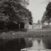
The ruin of the medieval parish church of Craignish stands in a rectangular burial-ground l00m from the W shore of Loch Craignish and 0.65km ESE of Craignish Castle (No. 121). It occupies the summit of a slight knoll, from which the ground drops steeply to N and E. The buildings of the former township of Kirkton, situated immediately to the S, replace earlier houses shown W of the burial-ground on an estate-map of 1797 (en.1).
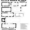
The church, which measures 14.5m by 6.lm within 0.9m walls, is roofless but otherwise complete, having been consolidated on two occasions during the present century. It probably dates from the early 13th century, but the masonry has been heavily repointed and most of the openings repaired, and the original character of the masonry is best seen in the inner face of the N wall, which is composed of angular blocks of local rubble with frequent pinnings, brought to regular courses.
The doorway, towards the W end of the S wall, appears to have been extensively remodelled in the late medieval period although the inner jambs are probably untouched. The outer jambs comprise square-arrised schist rybats carrying a semicircular arch-head which resembles that from Loch Glashan (No. 146), and the top of the inner opening was corbelled in to reduce the span of an inserted lintel. The splayed ingoes of the two pairs of windows in the S and E walls appear to be original, but the daylight-openings have been widened and given modern arch-heads, while the single window at the E end of the N wall has also been renewed externally although it retains its narrow daylight-width. The inner arch-heads of the S windows appear to be original but the others have been renewed. The E gable, which is intaken by two internal scarcements in the upper part, has weathered skewputts, probably of post-Reformation date. The W gable, which has been lowered, carries a small sandstone finial, perhaps connected with the use of the ruin as a burial enclosure.
It is possible that the W window of the pair in the S wall originally lit the E end of the nave, but the siting of two 16th centurytomb-chests against each side-wall indicates that at that period all of the windows were included in a chancel at least 5m long. There were two aumbries at a low level towards the ends of the E wall, and another in the S wall immediately E of the doorway, and 1m W of the SE angle there is a damaged sandstone block, at too low a level for a piscina, which may have been a lamp-bracket. The W end of the building was covered with a light roof in 1974, to protect the collection of carved stones (infra).
This church served a parish comprising the Craignish peninsula and an upland area bounded on the SE by the Barbreck River and on the N by the watershed with Kilmelfort. Although small compared with other parishes in Mid Argyll, it was unusual in that no proposals were made in the 1640s to alter its boundaries. The dedication was to St Maelrubha of Applecross, and early forms of the name include 'St Malroffe in Cragnich' (1440), 'Kilmolroy' (1580), 'Kilmolrw' (1602), 'Kilmolruy' (1626) and 'Kilmorie' (1626) (en.2). The names of parsons of Craignish are recorded from 1395, and of vicars from 1434, and it remained an independent parsonage until the reformation although the Earls of Argyll acquired the patronage during the 16th century. The vicarage was endowed with the merkland of 'Pennykill and Darrak , called Kilmolrwe', which in 1580 was granted in feu by the minister, Niall Campbell, as rector and vicar of Craignish, to his own natural son James Campbell; the vicar's manse and the four acres known as 'the Rector's Acre', however, were reserved to the incumbent. The feu of the property, 'called the Kirktoun', was transferred by James Campbell to a cousin in 1602 (en.3*).
The office of precentor of the diocese of Argyll was held by the minister of Craignish in 1622 and again from 1662, but nothing is known of the state of the building at this period. A new church erected in 1698 was probably on the site of the present one at Ardfern (No. 21) (en.4). The ruined church was repaired by the Craignish estate in the late 19th century, and further consolidation was carried out in 1926, with advice from the Office of Works, in advance of a proposed relocation of the medieval slabs from the churchyard (en.5). This proposal was abandoned because of local opposition, but was successfully revived by a local society, supported by the Natural History and Antiquarian Society of Mid Argyll, in 1974.
RCAHMS 1992, visited September 1987
[see RCAHMS 1992 No. 67 for a detailed description of 34 medieval and post-reformation funerary monuments and other carved stones]

