
Craignish Castle


Castle (16th Century)
Site Name Craignish Castle
Classification Castle (16th Century)
Alternative Name(s) Loch Beag
Canmore ID 22560
Site Number NM70SE 1
NGR NM 77168 01635
Datum OSGB36 - NGR
Permalink http://canmore.org.uk/site/22560


- Council Argyll And Bute
- Parish Craignish
- Former Region Strathclyde
- Former District Argyll And Bute
- Former County Argyll
NM70SE 1.00 77168 01635
NM70SE 1.01 NM 7721 0163 Tennis Court
1.02 NM 77260 01595 Castellated Cottage
1.03 NM 77650 01510 Gate Lodge
1.04 NM 77250 01585 Gardener's Cottage
1.05 Centred NM 774 017 Craignish Castle Policies, General
1.06 NM 77395 01582 Proposed House on site of Episcopal Chapel
(NM 7717 0164) Craignish Castle (NR)
OS 6" map, Argyllshire, 2nd ed., (1900)
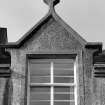
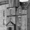
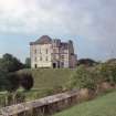
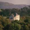
Craignish Castle was originally a simple 16th century keep, 41'9" x 33'6", with walls 7'6" thick, which has been much altered and forms part of a modern mansion, standing on a detached rock. The ground floor of the keep is vaulted, and there is a dungeon below, cut out of rock.
The mansion, recently restored (SDD 1960-) is 3 storeys high, with harled walls; an addition to the N, originally a long wing, now reduced, was made c. 1835. The SDD (1960-) note a rubble rampart to E.
D MacGibbon and T Ross 1887-92; SDD 1960-
Now completely harled, Craignish Castle (name confirmed) exhibits little of architectural interest.
There is no trace of the rubble rampart.
Visited by OS (JP) 14 October 1971.
NMRS REFERENCE
Craignish Castle.
ARCHITECT: William Burn, alterations 1837 ('Mr David Bryce', pp. 118-119).
I. G. Lindsay Collection, W/263.
EXTERNAL REFERENCE
Scottish Records Office:
A drawing by Andrew Elliot of the Castle, the seat of Colin Campbell of Jura.
Listed in Inventory.
1842 GD 64/1/413
Field Visit (April 1984)
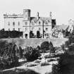
The much-altered and extended remains of this late medieval tower-house stand on a level tongue of land overlooking the head of Loch Beag, an inlet of the Sound of Jura about 3km from the SW end of the Craignish peninsula. In its existing form it comprises work of three main periods, together with at least two phases of alterations in the 20th century. The ground floor and part of the first floor of the three-storeyed tower-house occupying the S part of the site appear to represent work of late 14th- or early 15th-century date, the castle being recorded as incomplete in 1414. The remaining walls of the tower were subsequently reconstructed and the interior remodelled at some date in the 16th or 17th century, judging by a few surviving architectural features. A two-stage N range, in existence in 1797 (en.1), was added to the tower, but in 1837 these additions were replaced by two- and three-storeyed ranges in English Elizabethan style designed by William Burn (en.2), and the upper works of the tower were rebuilt at the same time. These additions have since been reduced to two of the original four bays of the three-storeyed N range, a two-storeyed stair-wing being added against the centre of the new N gable-wall, which was an original internal flue-bearing wall. The crenellated octagonal upper storey of the 1837 entrance-tower has also been reduced in height, while the tower-house itself is now covered with a high hipped roof.
RCAHMS 1992, visited April 1984
[A full architectural description and historical note is provided in RCAHMS 1992, 259-262]
Measured Survey (29 April 1984 - 30 April 1984)
RCAHMS surveyed Craignish Castle between 29-30 April 1984 producing ground-, first- and second-floor plans at a scale of 1:100. The plans were redrawn in ink and published at a scale of 1:250 (RCAHMS 1992, 260C).
Measured Survey (9 May 1984)
RCAHMS surveyed Craignish Castle on 9 May 1984 with plane-table and alidade producing a site plan at a scale of 1:400. The plan was later redrawn in ink.

