
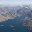
Eilean Nan Gobhar, Sound Of Arisaig


Fort (Period Unknown), Vitrified Stone (Period Unknown)
Site Name Eilean Nan Gobhar, Sound Of Arisaig
Classification Fort (Period Unknown), Vitrified Stone (Period Unknown)
Alternative Name(s) Eilean Nan Gobhar 1; South
Canmore ID 22509
Site Number NM67NE 1
NGR NM 6939 7939
Datum OSGB36 - NGR
Permalink http://canmore.org.uk/site/22509


- Council Highland
- Parish Arisaig And Moidart
- Former Region Highland
- Former District Lochaber
- Former County Inverness-shire
NM67NE 1 6938 7938.
See also NM67NE 2.
(NM 6938 7938) Vitrified Fort (NR) (Remains of)
OS 6"map, Argyllshire, 2nd ed., (1902)
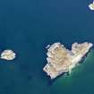
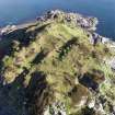
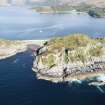
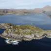
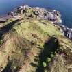
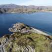
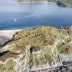
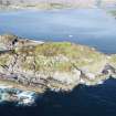
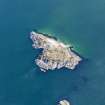
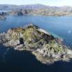
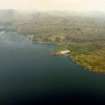
There are two vitrified forts on Eilean nan Gobhar, a rocky cliff-girt islet.
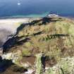
The larger (see NM67NE 2 for the other) occupies the summit of the isle and is sub-rectangular on plan, measuring c. 40.0m WNW - ESE by 22.0m transversely, within a heavily vitrified wall which survives on the S. to a maximum height of 2.5m. On the N. approximately 22.0m of the outer wall is visible, suggesting a width of 4.0m to 5.0m. No built masonry survives anywhere else and no entrance can be seen.
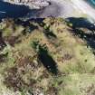
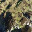
In the uneven interior of the fort are three stone-walled huts (A-C) each being a level circular platform surrounded by a rubble wall, spread to c. 20.0m in which no entrance or faces can be seen, and measuring c 8.0m. in diameter between wall centres. A and B have been built against the inner face of the fort wall but whether they are contemporary with the fort or later cannot be established because the remains of the wall are so slight. C is set into a west-facing slope.
About 10.0m outside the fort wall, on the south, are traces of a denuded wall showing intermittent outer facing stones and to the N of the E arc of the fort are traces of similar walling with one piece of vitrification at its N end. Although possibly part of an earlier work,their position, each at the head of a natural gully, the only means of access to the fort, suggests that they are supplementary defences. Each gully, c. 3.0m wide, is blocked by a tumbled wall half-way down the slope. Between the gullies the ground falls to the shore in a series of rocky scarps, near the bases of which all gaps in the rocks have been blocked by rough walling.
Visited by OS (N K B) 1 June 1970.
E Hamilton 1880; R W Feachem 1963.
Note (20 November 2014 - 18 May 2016)
Situated on the summit of this small island in the mouth of Loch Ailort, this small fortification is roughly trapezoidal on plan, measuring internally about 40m in length and ranging from 23m in length at the ESE end to 16m at the WNW end (0.08ha). The defences comprise a single wall with an extensively vitrified core still standing up to 2.5m high; it may have measured between 4m and 5m in thickness, though the only evidence of the wall-faces is a run of some 22m of the outer on the N. The position of the entrance is unknown, but the heads of gullies that may have provided access on the S and N have been blocked by traces of what may be an outer wall reduced to bands of rubble with occasional outer facing-stones, and the northern includes at least one piece of vitrifaction. Keith Blood, the OS surveyor who visited in 1970 and noted these remains, considered the possibility that they belonged to an earlier and larger enclosure, but on balance interpreted them as outworks; he also observed other fragments of rough walling blocking the gullies further down the slope and filling all the gaps in the outcrops around the foot of the hillock; the relationship of these remains to the summit enclosure is unknown. Within the interior there are three circular stone-founded structures, each about 6m in internal diameter, two of which are set against the inner line of the wall, though the stratigraphic relationship is uncertain.
Information from An Atlas of Hillforts of Great Britain and Ireland – 18 May 2016. Atlas of Hillforts SC2535

