 |
On-line Digital Images |
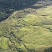
DP 094496 |
RCAHMS Aerial Photography Digital |
Oblique aerial view of the field boundaries, rig and shieling huts, looking SSW. |
30/8/2010 |
Item Level |
|
 |
On-line Digital Images |
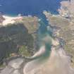
DP 109079 |
RCAHMS Aerial Photography Digital |
Oblique aerial view of Kentra Bay, taken from the SE. |
30/4/2011 |
Item Level |
|
 |
On-line Digital Images |
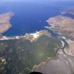
DP 109149 |
RCAHMS Aerial Photography Digital |
General oblique aerial view of Kentra Bay, taken from the SE. |
30/4/2011 |
Item Level |
|
 |
On-line Digital Images |
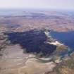
DP 109150 |
RCAHMS Aerial Photography Digital |
General oblique aerial view of Kentra Bay, taken from the E. |
30/4/2011 |
Item Level |
|
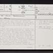 |
On-line Digital Images |
SC 2383280 |
Records of the Ordnance Survey, Southampton, Hampshire, England |
Ardnamurchan, Cul Na Croise, NM66NW 2, Ordnance Survey index card, page number 1, Recto |
1958 |
Item Level |
|
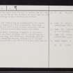 |
On-line Digital Images |
SC 2383281 |
Records of the Ordnance Survey, Southampton, Hampshire, England |
Ardnamurchan, Cul Na Croise, NM66NW 2, Ordnance Survey index card, page number 2, Verso |
1958 |
Item Level |
|


