|
Photographs and Off-line Digital Images |
AG 7735 |
|
RCAHMS |
1976 |
Item Level |
|
|
Photographs and Off-line Digital Images |
AG 7736 |
|
RCAHMS |
1976 |
Item Level |
|
|
Photographs and Off-line Digital Images |
AG 7737 |
|
RCAHMS |
1976 |
Item Level |
|
|
Photographs and Off-line Digital Images |
AG 7738 |
|
RCAHMS |
1976 |
Item Level |
|
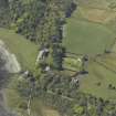 |
On-line Digital Images |
DP 029658 |
RCAHMS Aerial Photography Digital |
Oblique aerial view centred on the towerhouse, country house, walled garden and farmsteading, taken from the SE. |
3/5/2007 |
Item Level |
|
|
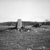
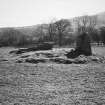
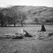
Photographs and Off-line Digital Images |
H 97520 S |
Allard Johnson |
Long Chambered Cist, Scallastle. |
1952 |
Item Level |
|
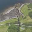 |
On-line Digital Images |
DP 139475 |
RCAHMS Aerial Photography Digital |
Oblique aerial view centred on Craignure Golf Club, looking NE. |
19/7/2012 |
Item Level |
|
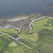 |
On-line Digital Images |
DP 139477 |
RCAHMS Aerial Photography Digital |
Oblique aerial view centred on Craignure Golf Club, looking NE. |
19/7/2012 |
Item Level |
|
 |
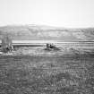
On-line Digital Images |
SC 2250144 |
|
RCAHMS |
1976 |
Item Level |
|
 |
On-line Digital Images |
SC 2250145 |
|
RCAHMS |
1976 |
Item Level |
|
 |
On-line Digital Images |
SC 2250146 |
|
RCAHMS |
1976 |
Item Level |
|
 |
On-line Digital Images |
SC 2250147 |
|
RCAHMS |
1976 |
Item Level |
|
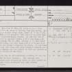 |
On-line Digital Images |
SC 2383082 |
Records of the Ordnance Survey, Southampton, Hampshire, England |
Mull, Scallastle, NM63NE 2, Ordnance Survey index card, page number 1, Recto |
1958 |
Item Level |
|
 |
On-line Digital Images |
SC 2383083 |
Records of the Ordnance Survey, Southampton, Hampshire, England |
Mull, Scallastle, NM63NE 2, Ordnance Survey index card, page number 2, Verso |
1958 |
Item Level |
|
 |
On-line Digital Images |
SC 2383084 |
Records of the Ordnance Survey, Southampton, Hampshire, England |
Mull, Scallastle, NM63NE 2, Ordnance Survey index card, Recto |
1958 |
Item Level |
|
|
All Other |
551 166/1/1 |
Records of the Ordnance Survey, Southampton, Hampshire, England |
Archaeological site card index ('495' cards) |
1947 |
Sub-Group Level |
|


