
Mull, Scallastle


Standing Stone(S) (Prehistoric)
Site Name Mull, Scallastle
Classification Standing Stone(S) (Prehistoric)
Canmore ID 22404
Site Number NM63NE 2
NGR NM 6999 3827
Datum OSGB36 - NGR
Permalink http://canmore.org.uk/site/22404


- Council Argyll And Bute
- Parish Torosay
- Former Region Strathclyde
- Former District Argyll And Bute
- Former County Argyll
NM63NE 2 6999 3827.
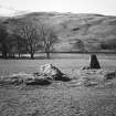
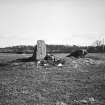
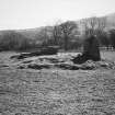
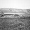
NM 6999 3827. The site of this (?) cairn is in a flat field under 50ft OD, about a furlong from the shore. All that remains is a slight stony rise, about 31ft by 17ft, oriented ESE-WNW; it is possible that this is no more than an old dump of field-gathered stones. At the WNW end of the rise there is an upright stone, 4ft 2ins high, its broader sides facing WSW and ENE. Nearly 11ft ESE there is a large prone slab, its main axis just N of E and S of W. Both stones are rather irregular in shape. It has been suggested (Betts and Cregeen 1957) that the slabs may have formed a chamber in a cairn, but the remains are too slight to form an opinion as to the original nature of the site.
U V Betts and E R Creegen 1957; A S Henshall 1972.
Two further slabs lie in the immediate vicinity of the two stones mentioned by Miss Henshall (1972). The remains here suggest that there were originally three or four stones in line around which field clearance has been dumped.
Surveyed at 1:2500.
Visited by OS (RD) 19 May 1972.
(NM 6999 3827) Standing Stone (NR)
OS 1:10,000 map, (1976)
Standing Stones, Scallastle: In an arable field 200m N of Scallastle there are the remains of a linear setting of at least three standing stones. Only one of the stones is still upright; aligned NW and SE, it measures 1.2m in height and 0.9m by 0.55m at the base. About 3m to the SE is a fallen stone, 1.7m long by 1.3m broad and 0.5m thick, while a further 1m in the same direction is another fallen stone, now almost completely overgrown, which measures 2.1m long, 1m broad, and 0.25m thick. The presence round these stones of a number of boulders cleared from the field in recent times is presumably responsible for the fact that the alignment was erroneously identified (a, supra) as a chambered cairn.
RCAHMS 1980, visited June 1972.

