
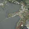
North Queensferry Harbour, Railway Pier


Pier (19th Century)
Site Name North Queensferry Harbour, Railway Pier
Classification Pier (19th Century)
Alternative Name(s) St Margaret's Yacht Club; St Margaret's Haven; St Margaret's Bay; Queensferry Narrows; Queensferry Passage
Canmore ID 222465
Site Number NT18SW 98.01
NGR NT 12840 80249
Datum OSGB36 - NGR
Permalink http://canmore.org.uk/site/222465


- Council Fife
- Parish Inverkeithing
- Former Region Fife
- Former District Dunfermline
- Former County Fife
NT18SW 98.01 12840 80249
See also:
NT18SW 98.02 NT 12840 80249 Watching Brief
Formerly entered as NT18SW 248.00.
Railway Pier [NAT]
OS 1:2500 map, 1966.
The location assigned to this record defines the mispoint of the structure. The available (GIS) map evidence indicates that it extends from NT c. 12481 80155 to NT c. 12803 80476.
Information from RCAHMS (RJCM), 6 March 2006.
Site recorded by Maritime Fife during the Coastal Assessment Survey for Historic Scotland, Kincardine to Fife Ness 1996
Publication Account (1999)
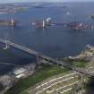
So called, from 1877, when the railway reached North Queensferry, the pier was used by train passengers who alighted here, took a ferry boat over to Port Edgar and caught another train on the other side. This railway line was soon to be superseded by another, with the building of the Forth Railway Bridge figures 17 & 18 in 1883-90.
Information from ‘Historic North Queensferry and the Peninsula: The Archaeological Implications of Development’ (1999).

