
Eigg, An Sgurr


Fort (Iron Age)
Site Name Eigg, An Sgurr
Classification Fort (Iron Age)
Alternative Name(s) Scuir Of Eigg
Canmore ID 22190
Site Number NM48SE 6
NGR NM 46120 84740
Datum OSGB36 - NGR
Permalink http://canmore.org.uk/site/22190


- Council Highland
- Parish Small Isles
- Former Region Highland
- Former District Lochaber
- Former County Inverness-shire
NM48SE 6 4612 8474.
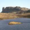
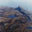
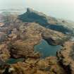
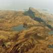
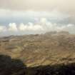
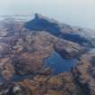
(NM 461 847) A fort, 1320' long and 300' broad, with an area of more than 9 acres, lies on the east end of An Sgurr, a sheer-sided table of pitchstone 400' high.
R W Feachem 1963
The only approach is from the west, up a steep and rocky ascent, which has been barred by a drystone wall, 10' thick and 250' long, which connects the brinks of the north and south precipices. An entrance 5' wide exists towards the southern end. The wall is now mainly scree.
RCAHMS 1928, visited 1925
A fort generally as described by Feachem and RCAHM. The wall has followed the brink of a W-facing slope and is best preserved towards its N end where the outer face survives to a height of 1.7m. The wall thickness appears to be about 3.2m. Elsewhere the wall has slipped away and survives as a band of loose debris on the slope. RCAHMS's alleged entrance is about 30.0m from the S end where there are traces of a debris-filled gap showing no structural features. A similar but more obvious gap occurs about 20.0m from the N end of the wall. There are no traces of internal occupation.
Visited by OS (ISS) 4 May 1972
Field Visit (8 July 1925)
Fort, An Sgurr.
The Sgurr of Eigg, a great wall of pitchstone, almost everywhere columnar, rising to an altitude of 1289 feet above the sea and 400 feet sheer above its base, is possibly the most impressive fort site in Scotland. The sides of the ridges are quite vertical and unscaleable and access is possible only towards the west, where the ridge is divided by a steep corry. The access on the face to the higher level has been barred by building a stout drystone wall 10 feet in thickness across the site, at this point some 250 feet broad. A gap in the wall, 5 feet wide, towards the southern end represents the entrance. The wall is now mainly scree. The enclosure so formed, over 9 acres in area, is ¼ mile in length and is rather less than 100 yards in width.
RCAHMS 1928, visited 8 July 1925.
OS map: Islands of Eigg and Muck (Inverness-shire) lxxii and lxxiii (unnoted).
Field Visit (9 July 2001)
An Sgurr is a pitchstone ridge whose striking profile forms a landmark visible for many miles around. The ridge rises towards the E from a plateau of high moorland, its N and S flanks becoming increasingly precipitous towards the summit, which is at the E end. Here the ridge terminates abruptly, with sheer cliffs falling about 120m. The only approach to the summit is from the W, and the way has been barred by a single drystone wall drawn across the ridge from N to S, about 450m W of the summit. The wall measures about 2.5m thick and for most of its length it stands about 0.5m high. However, the outer face rises to 1.8m towards its N end, where some reconstruction may have taken place in recent times. There is an entrance, about 30m short of the north end of the wall, which is used by the modern path to the summit and again it may be at least partly a modern reconstruction. The enclosed area measures about 470m by up to 120m, and amounts to some 5ha. No buildings or other archaeological features could be seen within the fort, the ground being rocky and uneven.
(EIGG01 260)
Visited by RCAHMS (MFTR) 9th July 2001
Note (13 November 2014 - 13 December 2016)
The Sgurr of Eigg, which is such a dramatic landmark from the seas round about is also the site of a fort formed by a single wall drawn across the ridge above the broad saddle midway along its spine. From that point eastwards, the ridge becomes progressively more rugged, with large sheets of outcrop and heather-clad slopes dropping into the edge of a sheer cliff up to 120m high extending around its E extremity. The wall measures up to 2.5m in thickness and, though it has largely collapsed, towards its N end stands up to 1.8m high, albeit some of the upper courses may be the result of reconstruction. The interior, which measures some 470m in length by up to 120m in breadth, is broken transversely by a succession of huge ribs of pitchstone and gullies, and little of it is suitable for any form of occupation. The only possible line of approach to the fort is from the W, and while in 1925 RCAHMS investigators suggested a debris strewn gap towards the S end of the wall was the entrance, the OS identified a gap towards the N end; it is not known whether either is original.
Information from An Atlas of Hillforts of Great Britain and Ireland – 13 December 2016. Atlas of Hillforts SC2527
Note
Written on rear of photograph IN/780;
'Wall across Scuirr of Eigg
"Along one of these ditch-like gaps, which serves to insulate the Eastern and highest portion of the Scuirr from all its other portions, we find fragments of a rudge wall of uncemented stones, the remains of an ancient hill-fort; which, with its natural rampart of rock on more of its four sides, more than a hundred yards in sheer descent, and with its deep ditch and rude wall on the ?fau..., must have formed one of the most inacessible in the kingdom." The Cruise of the ?Bekey p 41., Hugh Miller 1844(?)'

