
Eigg, Kildonnan


Cairn(S) (Viking), Chambered Cairn (Neolithic)(Possible)
Site Name Eigg, Kildonnan
Classification Cairn(S) (Viking), Chambered Cairn (Neolithic)(Possible)
Alternative Name(s) Kildonan
Canmore ID 22182
Site Number NM48SE 2
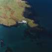
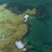
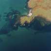
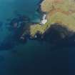
NGR NM 49006 84893
Datum OSGB36 - NGR
Permalink http://canmore.org.uk/site/22182


- Council Highland
- Parish Small Isles
- Former Region Highland
- Former District Lochaber
- Former County Inverness-shire
NM48SE 2 49006 84893
(NM 4899 8488) Cairns (NR)
OS 1:10000 map (1976)
Two adjoining tumuli, 500 to 600 yds S of Kildonnan, were excavated in 1875 by Prof MacPherson and A Joass and yielded Viking grave-goods, which were donated to the National Museum of Antiquities of Scotland (NMAS). Although the larger appeared to have been disturbed and no body was found, it yielded the following objects: fragments of an iron sword (Accession no: IL 160-1), a whetstone (IL 162), a silvered bronze penannular brooch (IL 163), a portion of a leather belt (IL 166) with buckle and clasp, (IL 159 & IL 165), an iron axehead (IL 167), small fragments of bone, beads etc., but no pottery or flint. Small fragments of woollen and linen cloth were also found (IL 164) (later confirmed by the Wool Industries Research Assoc. and the Shirley Institute (G M Crowfoot 1951)).
The smaller tumulus a few yards further S yielded another bonze penannular brooch (IL 173), splinters of flint, an iron sword (IL 174), a whetstone (IL 177), and beads of amber and jet (IL 170-2 and IL 175-6). The finds are dated to the second half of the 9th century AD.
N MacPherson 1878; NMAS Catalogue 1892; S Grieg 1940.
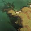
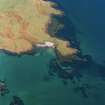
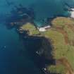
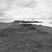
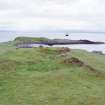
Two contiguous turf-covered cairns at NM 4899 8488, generally as planned by MacPherson. The westerly cairn measures about 12.0m in diameter and 1.2m high and has an excavation trench into the centre from the NW. The centre is partly filled with rubbish, but most of the stones forming the cist planned by MacPherson can be seen. It measures 1.1m NW-SE by at least 1.3m transversely. There is no trace of the SW end. The other cairn measures about 5.5m in diameter and is 0.5m high, with a central excavation in which no structure is exposed.
Surveyed at 1:10,000.
Visited by OS (AA) 8 May 1972
Note (1928)
NOTE.
In a contribution to the Proceedings of the Society of Antiquaries on March 11, 1878 (vol. xii., 577-597), mention is made of the following additional monuments:
(1) "Foundations of an island dwelling" in a small loch "lying high up on the shoulder of the Scuir of Eigg, known as Lochan na Mna Moire." The island is apparently that in Lochnam Ban Mora (O.S. 6-inch), the only loch here which has an island; it is inaccessible without a boat.
(2) A cairn, "some five or six hundred yards south from Kildonnan," which provided on excavation the articles in [RCAHMS 1928] No. 2 of list on p. lvi.
(3) A cairn "a few yards further south" with articles in No 3.
(4) Cairn, "Sithean or Sguman-nan-Cailleach," containing "two cists . . . made of flat stones set on edge and laid length wise." Stones of cairn removed to fill up a drain. Sithean na Cailleich on O.S. 6-inch lxxi
The O.S. map 6-inch lxxiii. notes a stone cist just north of Kildonnan Old Church ("Ruins of Chapel," cf. Proc. Soc. Ant. Scot., as above, pp. 584-6); the site of one stone cist found in 1861, and of another in 1864, in Galmisdale; the sites of two crosses (lxxi., lxxii.) and Tobar Challuim Chille ("Columba's Well") in Cleadale (lxxi).
RCAHMS 1928
Field Visit (12 October 2002)
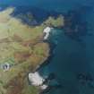
These two cairns stand side-by-side on a terrace above the shore about 120m S of Kildonnan farmhouse. That to the NW measures about 12m in diameter and 1.4m in height. The excavation trench driven into it from the NW in 1875, which was described by the Ordnance Survey in 1972, is still open and the cist slabs are still visible. The SE cairn measures 5.3m in diameter and 0.6m in height. The 1875 excavation trench is visible as a pit, slightly to the S of the centre of the cairn; it measures 2m by 1.3m and 0.5m in depth.
The larger cairn, at least, is probably a prehistoric structure reused for a Viking burial. Given the size of the cist (not all of which is visible) the possibility that this is a chambered cairn cannot be discounted.
Finally, short lengths of field bank extending to the W and NE from the larger cairn appear to pre-date the 19th-century excavations.
(EIGG01 497-8)
Visited by RCAHMS (AGCH) 12 October 2002

