 |
On-line Digital Images |
DP 192440 |
Dr Colin and Dr Paula Martin |
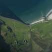
Aerial view from the SW. The farm of Laig is at lower centre with the former loch beyond it, indicated by uncultivated ground. Sròn Laimhrige (Rock of the Landing Place) is on the extreme right, above the small loch. (Colin Martin) |
c. 2014 |
Item Level |
|
 |
On-line Digital Images |
DP 192441 |
Dr Colin and Dr Paula Martin |
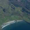
Aerial view from the SE. The farm of Laig is at lower centre. The northern part of the former loch is indicated by uncultivated ground to its right. Between the farm and the shore, on the raised beach, a complex of small square enclosures set in linear patterns is believed to be a Pictish cemetery. (Colin Martin) |
c. 2014 |
Item Level |
|
 |
On-line Digital Images |
DP 192442 |
Dr Colin and Dr Paula Martin |
Aerial view from the SW. The farm of Laig is lower right of centre with the former loch beyond it, indicated by uncultivated ground. Sròn Laimhrige (Rock of the Landing Place) is at top right, above the small loch. (Colin Martin) |
c. 2014 |
Item Level |
|
 |
On-line Digital Images |
DP 192443 |
Dr Colin and Dr Paula Martin |
Aerial view from the N. The farm of Laig is towards the right with the former loch to its left, indicated by uncultivated ground. Sròn Laimhrige (Rock of the Landing Place) is at top centre, topped by a triangular wood. (Colin Martin) |
c. 2014 |
Item Level |
|
 |
On-line Digital Images |
SC 2382466 |
Records of the Ordnance Survey, Southampton, Hampshire, England |
Eigg, Laig, NM48NE 3, Ordnance Survey index card, Recto |
1958 |
Item Level |
|
 |
On-line Digital Images |
SC 2382467 |
Records of the Ordnance Survey, Southampton, Hampshire, England |
Eigg, Laig, NM48NE 3, Ordnance Survey index card, Recto |
1958 |
Item Level |
|
 |
On-line Digital Images |
SC 2382468 |
Records of the Ordnance Survey, Southampton, Hampshire, England |
Eigg, Laig, NM48NE 3, Ordnance Survey index card, Recto |
1958 |
Item Level |
|
 |
On-line Digital Images |
SC 2382469 |
Records of the Ordnance Survey, Southampton, Hampshire, England |
Eigg, Laig, NM48NE 3, Ordnance Survey index card, Recto |
1958 |
Item Level |
|
|
All Other |
551 166/1/1 |
Records of the Ordnance Survey, Southampton, Hampshire, England |
Archaeological site card index ('495' cards) |
1947 |
Sub-Group Level |
|


