
Mull, Glengorm


Standing Stone(S) (Prehistoric)
Site Name Mull, Glengorm
Classification Standing Stone(S) (Prehistoric)
Canmore ID 22078
Site Number NM45NW 2
NGR NM 4347 5713
Datum OSGB36 - NGR
Permalink http://canmore.org.uk/site/22078


- Council Argyll And Bute
- Parish Kilninian And Kilmore
- Former Region Strathclyde
- Former District Argyll And Bute
- Former County Argyll
NM45NW 2 4347 5713.
(NM 4347 5713) Standing Stones (NR)
OS 1:10000 map (1976)
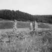
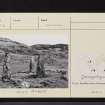
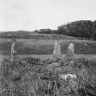
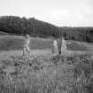
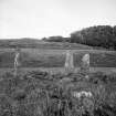
Three standing stones occupy a commanding position on the end of a ridge of broken ground W of Glengorm Castle. In the early 1800s only one of the stones (B on plan) was upright (J Duns 1883), but the other two had been re-erected by 1942 (information from V G Childe MS notebook, held in NMRS). The stones are surrounded by a modern enclosure-bank and the packing-stones visible at the bases of A and C must also be of recent date.
Stone A measures 2.05m in height, 0.78m in breadth, and 0.36m in thickness at the base; it leans slightly to the SE, with flattish sides and a rounded top. Stone B, aligned N and S, is 2.1m high and 2.3m in girth at the base. Stone C measures 2.15m in height by 0.5m at the base; the sides are flat and the top sloping.
The existence of a large mound of stones nearby was recorded in 1883, by Duns, but it is no longer visible, and it is not clear from the description whether it was a prehistoric burial cairn or not.
RCAHMS 1980, visited 1973
'Two standing stoes, supposed to be the remains of a circle.'
Name Book 1878
Three standing stones, as described by the RCAHMS. There is no evidence that they formed part of a stone circle.
Surveyed at 1:2500.
Visited by OS (DWR) 19 April 1972
The site was excavated as part of a four week survey of the stone alignments of northern Mull. The northernmost of the three stones appears to have been re-erected near its original position, while the southernmost stone has been dragged NE, to be wedged upright in a cleft in the bedrock. The original alignment did not repeat the trend of other sites in the area. Further conclusions await processing of the survey data.
A clay pipe bowl was found near the northernmost stone. It bears an embossed head and the inscription 'George V'. Other finds were pebbles of chalk, quartz and flint, some of these last apparently having been almost vitrified by intense heat. A small pit containing charcoal was found near the centre stone and cremated bone was found to the SW of the northernmost stone on the last afternoon of the excavation. An 8m core was taken from a nearby bog for pollen analysis. Data collected by field walking around all the standing stone alignments in the area will be used to analyse the locations of these sites.
R Martlew and C Ruggles 1987.
Field Visit (29 July 1942)
This site was included within the RCAHMS Emergency Survey (1942-3), an unpublished rescue project. Site descriptions, organised by county, vary from short notes to lengthy and full descriptions and are available to view online with contemporary sketches and photographs. The original typescripts, manuscripts, notebooks and photographs can also be consulted in the RCAHMS Search Room.
Information from RCAHMS (GFG) 10 December 2014.

