
Rum, Harris 1


Field System (Post Medieval), Head Dyke (Post Medieval), Township (Post Medieval)
Site Name Rum, Harris 1
Classification Field System (Post Medieval), Head Dyke (Post Medieval), Township (Post Medieval)
Alternative Name(s) Rhum
Canmore ID 21948
Site Number NM39NW 8
NGR NM 3393 9586
NGR Description centred on NM 3393 9586
Datum OSGB36 - NGR
Permalink http://canmore.org.uk/site/21948


- Council Highland
- Parish Small Isles
- Former Region Highland
- Former District Lochaber
- Former County Inverness-shire
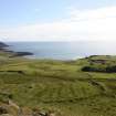
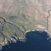
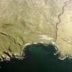
Harris The island's largest settlement in the 18th century, cleared and today reduced to the ruins of some 30 pre-1826 blackhouses scattered about the mouth of Glen Duain River. There is also a shepherd's cottage, and one of a pair of timber-lined shooting lodges built in 1889 by John Bullough and originally equipped with bellpulls etc; it is now a bothy. The other, almost identical, lies in ruin at Papadil.
Taken from "Western Seaboard: An Illustrated Architectural Guide", by Mary Miers, 2008. Published by the Rutland Press http://www.rias.org.uk

The largest building noted was 14.5m by 6.3m within walls built of rubble and earth and were up to 1.8m wide. A few buildings are reduced to foundation level. In the most complex area, three phases of structural history are represented.
NMRS MS/868/1
Field Visit (May 1983)
Harris 1 NM 338 959 NM39NW
The township of Harris comprises thirty-seven buildings ranging in size from 12.9m by 4.6m to 3.4m by 2.2m, although the majority are between 5m and 10m in length and between 2.5m and 4m in width between thick drystone walls. Whilst many of the buildings probably relate to the immediately pre-clearance period, at least five are earlier and others may be so (see also NM39NW 9). Around the township its fields of rig-and-furrow cultivation remain largely undisturbed by later activity. Harris may be the settlement named 'Kaming' on Pont's map. (See also NM39NW 9).
RCAHMS 1983, visited May 1983
(Pont 1654; Love 1983, 11)
Note (6 December 1996)
Five roofed, nineteen unroofed buildings, ten enclosures, a field-system (NM 336 964 to 344 956) and parts of a head-dyke are depicted on the 1st edition of the OS 6-inch map (Argyllshire, Islands of Rum, Sanday etc., 1879, sheet lxvi). Within the boundary of the township are five groups of shieling-huts (NM39NW 20, 21, 25, 26, 34) and a group of cairns, enclosures and possible huts (NM39NW 3, 4, 27).
Three roofed buildings, one of which is annotated as a mausoleum (NM39NW 60), twenty-eight unroofed buildings, eight enclosures, the remains of the field-system and parts of a head-dyke are shown on the current edition of the OS 1:10000 map (1975).
Information from RCAHMS (SAH) 6 December 1996
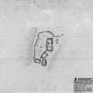
Measured Survey (23 August 2011)
A plan of four buildings and an enclosure centred at NM 3385 9584, part of the township of Harris (NM93NW 8), was undertaken at a scale of 1:250 using a plane table and self-reducing alidade. The plan was later used as the basis for an illustration published in 2016 at a scale of 1:500 (Hunter, fig. 5.27).
Visited by RCAHMS (GFG, IP) 23 August 2011.

